A Complete Month-by-Month Revision Plan to Clear RAS Prelims This December
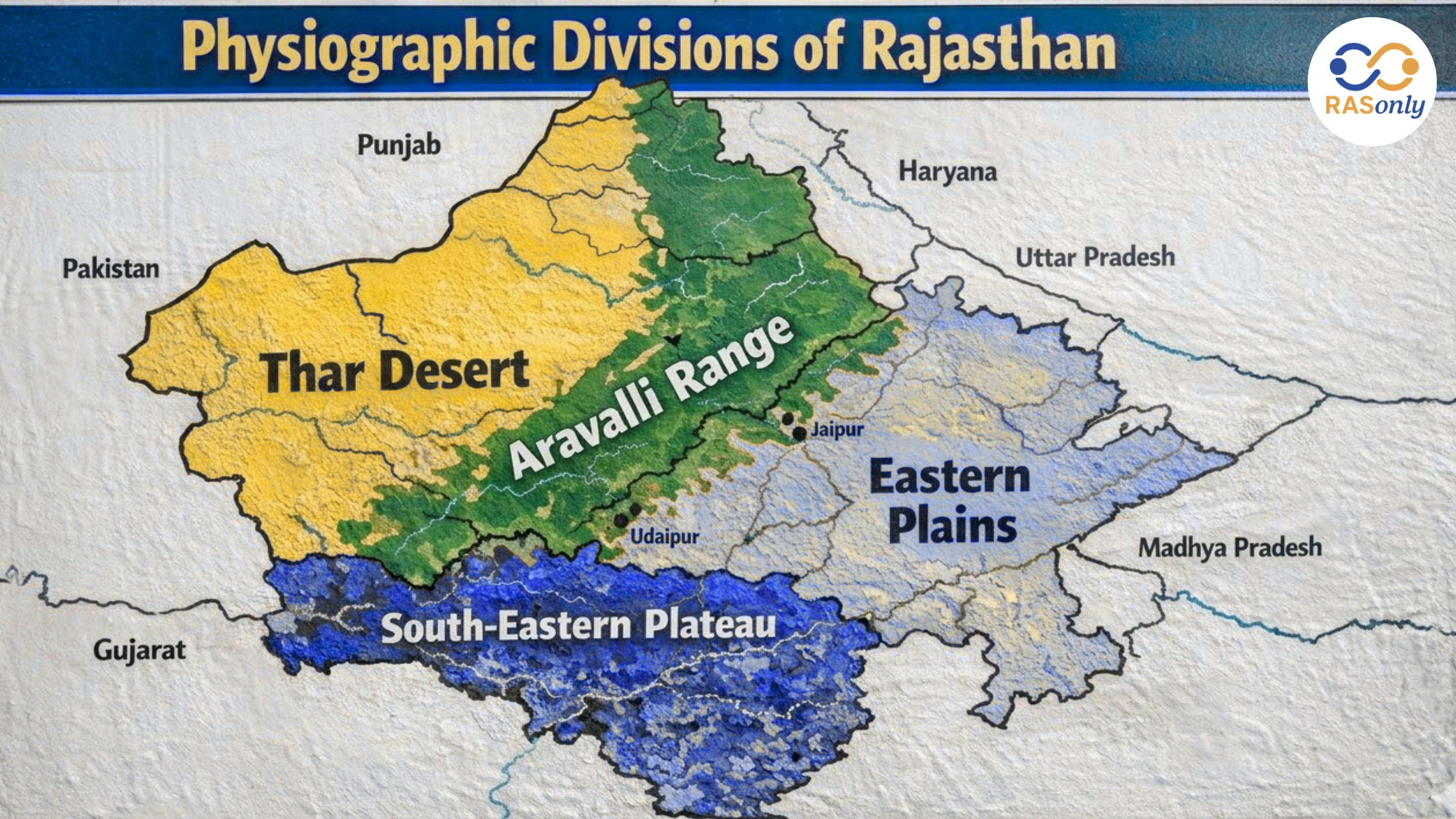
Physiographic Divisions of Rajasthan: Complete Geography, Structure, Features, Map & Importance (RAS 2026)

Get in Touch with RASonly!

The Physiographic Divisions of Rajasthan include the Thar Desert, Aravalli Range, Eastern Plains, and Hadoti Plateau, each with unique geographical features. These divisions influence climate, agriculture, water resources, and settlement patterns across the state. This topic is highly important for RPSC RAS 2026, Rajasthan GK, and Geography preparation.


The Physiographic Divisions of Rajasthan refer to the natural physical regions of the state formed due to geological evolution, tectonic activities, weathering, and erosion processes over millions of years. Rajasthan presents a unique geographical contrast where arid deserts, ancient mountain ranges, fertile plains, and plateau regions coexist, making it one of the most diverse states in India in terms of physical geography.
For RPSC RAS 2026, Rajasthan GK, Indian Geography, and Environment, understanding the physiography of Rajasthan, Aravalli Range, Thar Desert, Eastern Plains, and Hadoti Plateau. The divisions affect the climatic patterns, rainfall patterns, drainage system, soil formation, agriculture, vegetation, mineral resources, and human settlement, and hence this subject is of high importance to Prelims and Mains exams.
Overview of Physiographic Divisions of Rajasthan
The physiographic environment of Rajasthan is widely subdivided into four major divides, which are managed by relief, geological formation and climatic conditions. The Aravalli Range serves as the physiographical backbone of the state of Rajasthan subdividing it into two large physical regions.
| Division | Region | Nature | Key Importance |
|---|---|---|---|
| Western Sandy Plains | West Rajasthan | Desert | Water scarcity, dunes |
| Aravalli Range | Central Rajasthan | Mountain | Climate divide |
| Eastern Plains | East Rajasthan | Fertile plains | Agriculture |
| South-Eastern Plateau | South-East Rajasthan | Plateau | Irrigation & minerals |
Around 60% of Rajasthan lies west of Aravalli (desert) and 40% lies east (fertile region) — this is a very important exam fact.
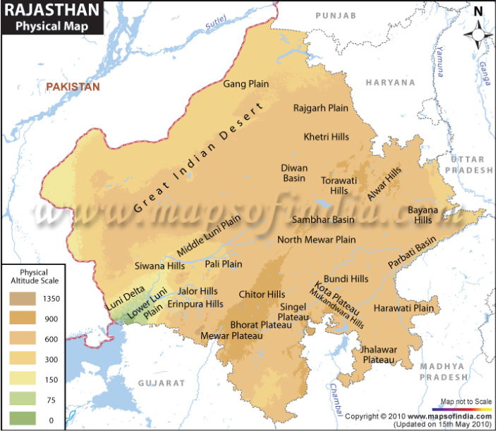
1. Western Sandy Plains (Thar Desert Region)
The Thar Desert or the Western Sandy Plains constitute the major physiographic subdivision of Rajasthan. This is a region that spans Jaisalmer, Barmer, Bikaner, Jodhpur, Nagaur, Churu, Hanumangarh and Ganganagar.
This division represents hot desert climate, sand dune topography, and extreme water scarcity, making it a key topic in Rajasthan Geography and Environment.
Detailed Features
- Dominance of sand dunes (Barchans, longitudinal dunes)
- Rainfall between 100–300 mm (very low)
- High temperature range (summer up to 48°C, winter near 0°C)
- Wind erosion and desertification processes
- Sparse vegetation (xerophytes like khejri, cactus)
- Inland drainage system (Luni River)
Sub-Regions
| Sub-Region | Description |
|---|---|
| Marusthali | Core desert |
| Luni Basin | Drainage region |
| Shekhawati | Semi-arid |
| Ghaggar Plains | Northern tract |
This region faces issues like drought, water scarcity, salinity, and desert expansion, which are important for RAS mains answers.
2. Aravalli Range and Hilly Region
The Aravalli Range and Hilly Region of Rajasthan is the most important physiographic division, forming the central backbone of the state’s geography. It is one of the oldest fold mountain systems in the world, extending from Mount Abu in the southwest to Khetri in the northeast, and plays a crucial role in shaping Rajasthan’s physical and climatic conditions.
This area plays a significant role in the field of RPSC RAS 2026, Rajasthan Geography, and Environment because it regulates the rainfall, rivers, minerals, forests, and ecology. The Aravalli Range is a natural barrier between the dry Thar Desert and the fertile eastern plains and therefore it is an essential concept in exam preparation.
Detailed Features
- Length: approx. 700–850 km
- Highest peak: Guru Shikhar (1722 m)
- Acts as a climatic barrier (restricts desert expansion)
- Rich in minerals: copper (Khetri), zinc (Zawar), marble (Makrana)
- Forest cover mainly in southern region (Udaipur, Mount Abu)
Functional Importance
- Divides Rajasthan into desert west and fertile east
- Source of rivers like Banas and Sabarmati
- Controls rainfall pattern and ecological balance
- Prevents expansion of the Thar Desert
Sub-Divisions
| Region | Location |
|---|---|
| Alwar Hills | North-east Rajasthan |
| Ajmer Range | Central Rajasthan |
| Mewar Hills | Southern Rajasthan |
| Abu Region | Highest elevation (Mount Abu) |
The Aravalli Range is often called the “lifeline of Rajasthan geography” due to its role in climate, water resources, and natural balance.
3. Eastern Plains of Rajasthan
Eastern Plains of Rajasthan are located to the eastern side of the Aravalli Range and are the most fertile and the most developed part of the state in terms of agriculture. This area has districts like Jaipur, Alwar, Bharatpur, Dholpur, Kota and Bundi that have been better supplied by rain and river systems to support agriculture and settlements.
This division is highly important for RPSC RAS 2026, Rajasthan GK, and Geography, as it explains population distribution, agriculture, river systems, and economic development. Compared to western Rajasthan, this region has more water availability and favorable climatic conditions.
Detailed Features
- Fertile alluvial soil suitable for agriculture
- Rainfall between 400–800 mm annually
- High population density and urban development
- Major crops: wheat, mustard, barley, sugarcane
- Well-developed irrigation system
Major River Systems
| Basin | Rivers |
|---|---|
| Chambal Basin | Chambal, Kali Sindh, Parvati |
| Banas Basin | Banas, Berach, Kothari |
| Banganga Basin | Banganga River |
This region is known as the “agricultural heartland of Rajasthan”, contributing significantly to food production and economic growth.
4. South-Eastern Plateau (Hadoti Plateau)
The South-Eastern Plateau of Rajasthan and the South-Eastern Plateau of Arawati is in Kota, Bundi, Baran and Jhalawar districts. It is located on the Malwa Plateau and is geologically the volcanic rocks, which is why it is not similar to other parts of Rajasthan.
This region is highly important for RAS Mains (analytical geography) and Rajasthan GK, as it represents a well-irrigated, agriculturally rich, and resource-abundant area with strong river networks and fertile soil conditions.
Detailed Features
- Formed by basaltic rocks (Deccan Trap origin)
- Presence of black cotton soil (regur)
- Higher rainfall compared to rest of Rajasthan
- Dense river network and irrigation facilities
- Suitable for commercial crops
Major Rivers
- Chambal River
- Kali Sindh River
- Parvati River
This is the most agriculturally productive and irrigated region of Rajasthan, often referred to as the “green zone of the state”.
Climatic and Environmental Impact
The physiographic divisions of Rajasthan are significant in defining the climate, environment and natural resources of the state. The difference in relief has a direct influence on the distribution of rainfall, temperature, vegetation and availability of water among regions.
This topic is important for RAS 2026 Geography and Environment, as it connects physical geography with real-world issues like drought, agriculture, and climate change.
Key Impacts
- Rainfall pattern: Eastern Rajasthan > Western Rajasthan
- Temperature variation across region
- Vegetation difference: desert shrubs vs forests
- Water availability and river systems
- Agricultural
Example:
- Western Rajasthan → Hot desert climate
- Eastern Rajasthan → Semi-humid climate
Economic and Environmental Importance
The physiographic structure of Rajasthan directly influences the economic development, agriculture, natural resources, and environmental sustainability of the state. Each region has its own role in shaping the economy and livelihood of people.
This topic is highly important for RAS Mains (Geography + Development) and helps in writing analytical answers.
Key Importance
- Determines agriculture and cropping patterns
- Influences mineral distribution (Aravalli region)
- Affects urbanization and industrial growth
- Helps in water resource planning and irrigation
- Important for disaster management (droughts, floods)
Physiographic Order of Rajasthan (Exam Important)
The physiographic order of Rajasthan (East to West) is one of the most frequently asked concepts in RPSC RAS Prelims, Rajasthan GK, and Geography exams. Understanding this sequence helps aspirants clearly visualize the physical layout of Rajasthan, which is essential for solving map-based and conceptual questions.
This order is based on the natural progression of landforms from the south-eastern plateau region to the north-western desert region, and it reflects changes in relief, climate, soil, vegetation, and water availability across the state.
East to West Physiographic Order of Rajasthan
- Hadoti Plateau (South-Eastern Plateau)
- Eastern Plains (Alluvial Plains Region)
- Aravalli Range (Central Mountain System)
- Western Sandy Plains (Thar Desert Region)
Importance for RPSC RAS 2026
The topic Physiographic Divisions of Rajasthan is a high-weightage area in RAS Prelims, Mains, and Rajasthan GK. It covers both factual and analytical aspects of geography and is frequently asked in exams.
A strong understanding of this topic helps aspirants link physical geography with climate, agriculture, and development, which is essential for scoring well.
Exam Relevance
RAS Prelims:
- Direct questions on divisions, rivers, and features
RAS Mains:
- Analytical answers on geography and development
Rajasthan GK:
- Static + conceptual understanding
Important Topics to Focus:
- Aravalli Range and its role
- Thar Desert characteristics
- Hadoti Plateau features
- Eastern vs Western Rajasthan
Conclusion
The Physiographic Divisions of Rajasthan offer a clear insight of physical landscape diversities of the state such as Thar Desert, Aravalli Range, Eastern Plains, and Hadoti Plateau. The divisions are very important in determining climate, rainfall, river network, agriculture, mineral resources and the settlement patterns in Rajasthan.
For RPSC RAS 2026 aspirants, it is observed that good knowledge on the physiography of Rajasthan assists in connecting between geography and practical knowledge such as water shortage, agriculture and development in the area. The subject is very significant both in Prelims (factual questions) and Mains (analytical answers) exams and is therefore a prerequisite to good marks in the exam.
FAQ
Rajasthan is divided into four major physiographic divisions: Western Desert, Aravalli Range, Eastern Plains, and South-Eastern Plateau (Hadoti).
The Aravalli Range is the most important feature as it divides Rajasthan into desert west and fertile east and influences climate and rivers.
The Western Sandy Plains (Thar Desert) is the largest physiographic division of Rajasthan.
The Eastern Plains are fertile, have better rainfall and river systems, and are important for agriculture and population settlement.
The correct east to west order is:
Hadoti Plateau → Eastern Plains → Aravalli Range → Thar Desert
Hadoti Plateau → Eastern Plains → Aravalli Range → Thar Desert
BEST SELLER
🏆 PRELIMS
RAS Pass
Prelims focused Hindi & English
₹399
✓
Prelims Topic-Wise Tests
✓
Subject-Wise Tests
✓
Full-Length Prelims Tests
✓
Daily Current Affairs Tests
✓
Prelims PYQs Tests
✓
Detailed Solutions & Analysis
✓
All Rajasthan Ranking
✓
Unlimited Reattempts
✓
Mains Tests
✓
Hindi & English Tests
✓
All Rajasthan Ranking
Trusted by 5,000+ Students

Post Category
- RAS Salary
- Result
- RAS Admit Card
- RAS Job
- RAS Cutoff
- Preparation Tips
- RAS Answer Key
- RAS Exam Analysis
- RAS Syllabus
- RAS Previous Year Papers
- RPSC RAS Exam Pattern
- RAS Interview
- RAS Exam Date
- RAS Vacancy
- RAS Test Series
- RAS Best Books
- RAS Preparation Resources
- RAS Coaching Centre
- History
- Polity
- Geography
- Economics
- Science
- Art and Culture
- RPSC RAS Application Form
- RPSC RAS Notification
- RAS Eligibility Criteria
- UPSC Exam
- RPSC RAS Mains
Visit Our RASonly Offline Center
Our Expert Faculty

Bhunesh Sir
Current Affairs · 13+ Yrs

Aamir Khan Sir
RAS-2017 · IIM Ahm.

Akash Sir
Polity · 8+ Yrs
Free Resources
Official Mobile App

RASOnly App
by OTSAdda · Free
Full Video Lectures
Mock Tests & PYQs
Daily Current Affairs
AI Mock Interview
Free Download · No subscription needed to install
RAS 2024 Toppers — RASonly
Rank 2
Virendra Charan
Rank 9
Bhoopinder Singh
Rank 26
Aanchal Nagpal
Rank 33
Lokendra Singh
Rank 45
Amar Rathore
Rank 46
Manasvini Verma

Join RASonly WhatsApp Community
Get daily current affairs, exam alerts, free study material and tips from expert faculty — right on WhatsApp.
Join for Free →RASonly Interview Guidance Program

Mr. Ashok Jain
Ex-Chief Secretary Govt of Rajasthan
- IAS officer of the 1981 batch, Rajasthan cadre.
- Passionate about mentoring the next generation of RAS officers with real-world insights.
- Got retired in Dec 2017 from the post of Chief Secretary of the state of Rajasthan.

Mr. Guru Charan Rai
Ex-ASP / SP in Jaisalmer
- Guru Charan Rai, IPS (Retd), retired as Inspector General of Police (Security), Rajasthan, Jaipur in 2017.
- Served as ASP and SP in Jaisalmer, Nagaur, Sri Ganganagar, Sawai Madhopur, Dausa, Sikar, and Karauli.
- He also held key positions as DIGP and IGP in the Law and Order division.

Mr. Rakesh Verma
Ex-IAS Officer, B.Tech, MBA, and M.A. (Economics)
- IAS officer of the 1981 batch and retired in Chief Secretary Rank.
- Civil servant of high repute and vast experience.
- Has been teaching UPSC CSE subjects for the last six years.
Related Post


Daily Current Affairs for RAS Exam Preparation 2026
Rajasthan Solar Water Project 2026
July 31, 2026
Rajasthan Proposes 11 Major Reforms to PM Fasal Bima...
July 30, 2026