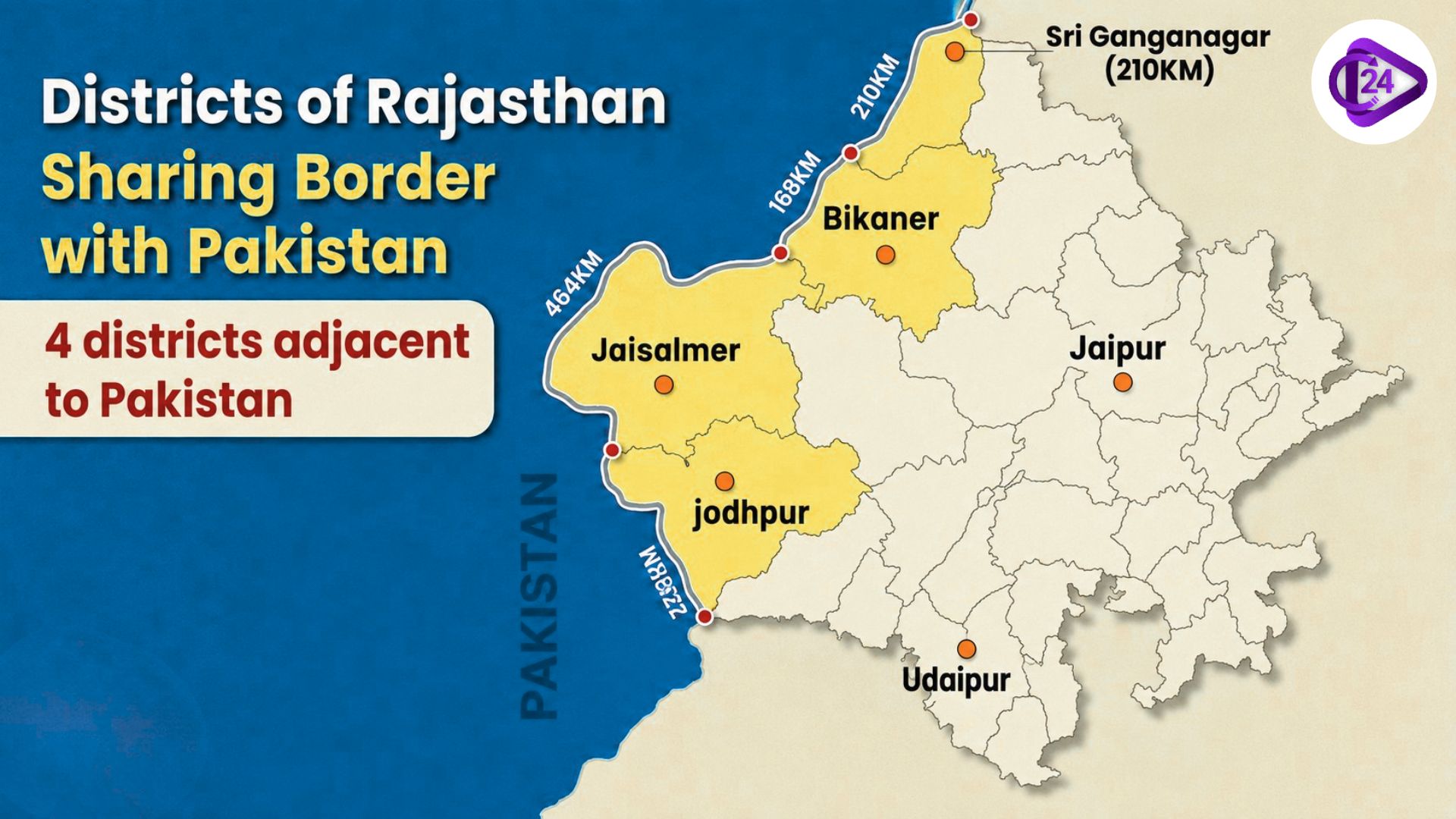
Districts of Rajasthan Sharing Border with Pakistan
Districts of Rajasthan Sharing Border with Pakistan

Get in Touch with RASonly!

Rajasthan Border Districts with Pakistan: Geography is a subject in RAS preparation where students often miss out on easy marks. Examiners frequently ask tricky questions about the four districts of Rajasthan that share a border with Pakistan. In this article, I have compiled comprehensive information about these four districts - ranging from border lengths to the 1971 Battle of Longewala—so that you can find everything in one place
Rajasthan, India's largest state by area, covering 342,239 sq km, shares a significant international boundary with Pakistan along its western frontier. This boundary, commonly known as the Radcliffe Line, stretches approximately 1,070 kilometers, making Rajasthan the Indian state with the longest international border with Pakistan.
This border runs from Hindumal Kot in Sri Ganganagar district (in the north) to Shahgarh in Barmer district (in the south), passing through the vast and inhospitable Thar Desert. The region holds immense strategic, economic, and historical importance for India.
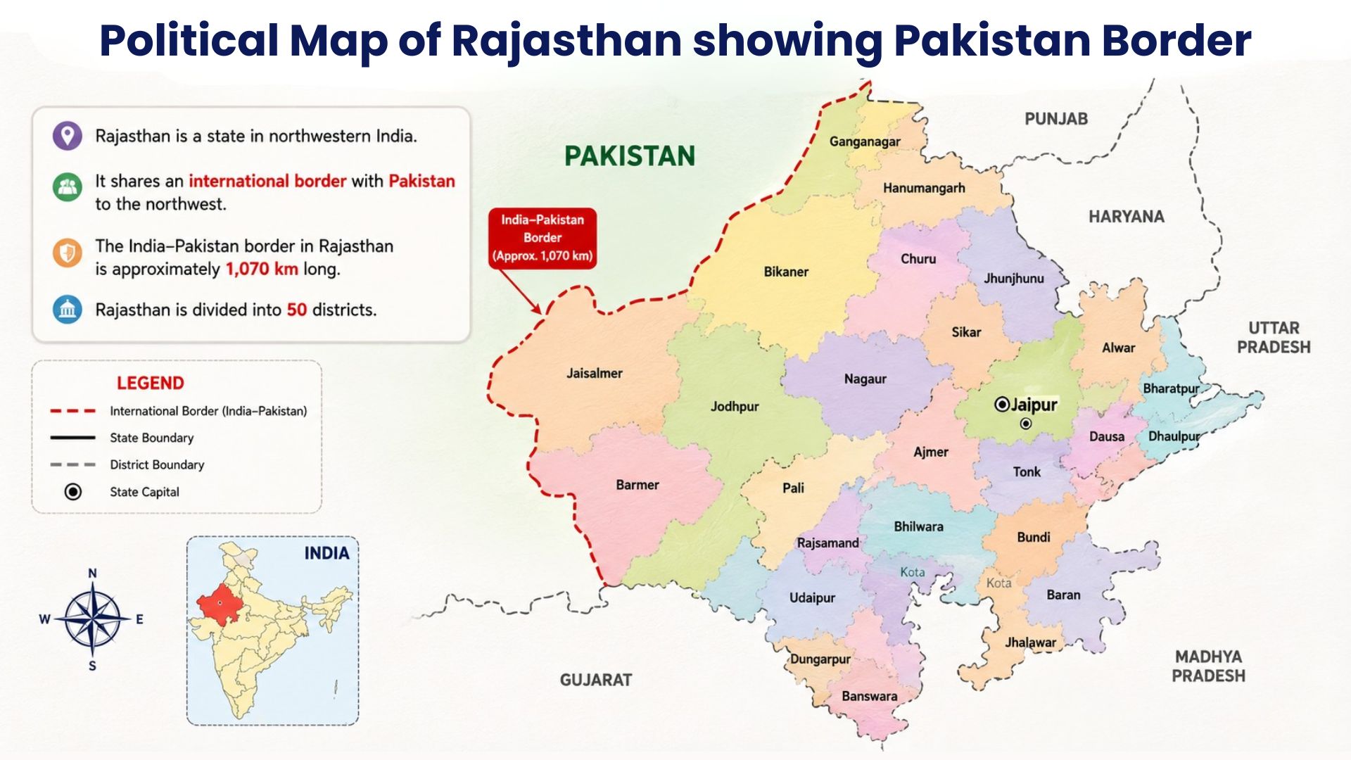
NOTE: Rajasthan's 1,070 km border with Pakistan is the LONGEST among all Indian states. This is a direct one-liner MCQ in RAS Prelims.
Key Facts at a Glance
Memorise these facts before reading the detailed district-wise analysis:
• Total international border length of Rajasthan with Pakistan: 1,070 km
• Number of districts sharing border with Pakistan: 4
• Hindumal Kot (Sri Ganganagar), Northern starting point of the border
• Shahgarh (Barmer), the southern ending point of the border
• Jaisalmer (464 km): District with the longest Pakistan border
• Bikaner (168 km): District with the shortest Pakistan border
• Punjab (northwest) and Sindh (west) Pakistani provinces adjoining Rajasthan
• Radcliffe Line (named after Sir Cyril Radcliffe, 1947) The border line is called
• Sri Ganganagar → Bikaner → Jaisalmer → Barmer North-to-South order of districts
District-wise Border Length Summary Table
| District | Border Length (km) | Pakistan Province | Key Feature |
|---|---|---|---|
| Sri Ganganagar | 210 km | Punjab (Pakistan) | Fertile land; Indira Gandhi Canal; agricultural hub |
| Bikaner | 168 km | Punjab (Pakistan) | Junagarh Fort; Thar Desert; lowest border length |
| Jaisalmer | 464 km | Punjab & Sindh | Longest border; Golden City; Longewala 1971 battle |
| Barmer | 228 km | Sindh (Pakistan) | Oil & gas reserves; Munabao border crossing |
The Radcliffe Line - Historical Background
The Radcliffe Line is the boundary demarcation between India and Pakistan, established during the Partition of British India in 1947. It was drawn by Sir Cyril Radcliffe, who chaired the boundary commission. The line was officially announced on 17 August 1947 - two days after independence.
Prior to Partition, the western districts of Rajasthan were closely connected with the regions that became Pakistan. The emergence of the international border drastically altered trade routes, cultural exchanges, and population movements in this region.
NOTE: The Radcliffe Line was drawn in 1947. Sir Cyril Radcliffe chaired the boundary commission. The border was announced on 17 August 1947 - always remember this date.
The Four Border Districts - Detailed Analysis
Exactly four districts of Rajasthan share their boundary with Pakistan. Each has a unique geographical, strategic, and economic character. They are described below in order from north to south:
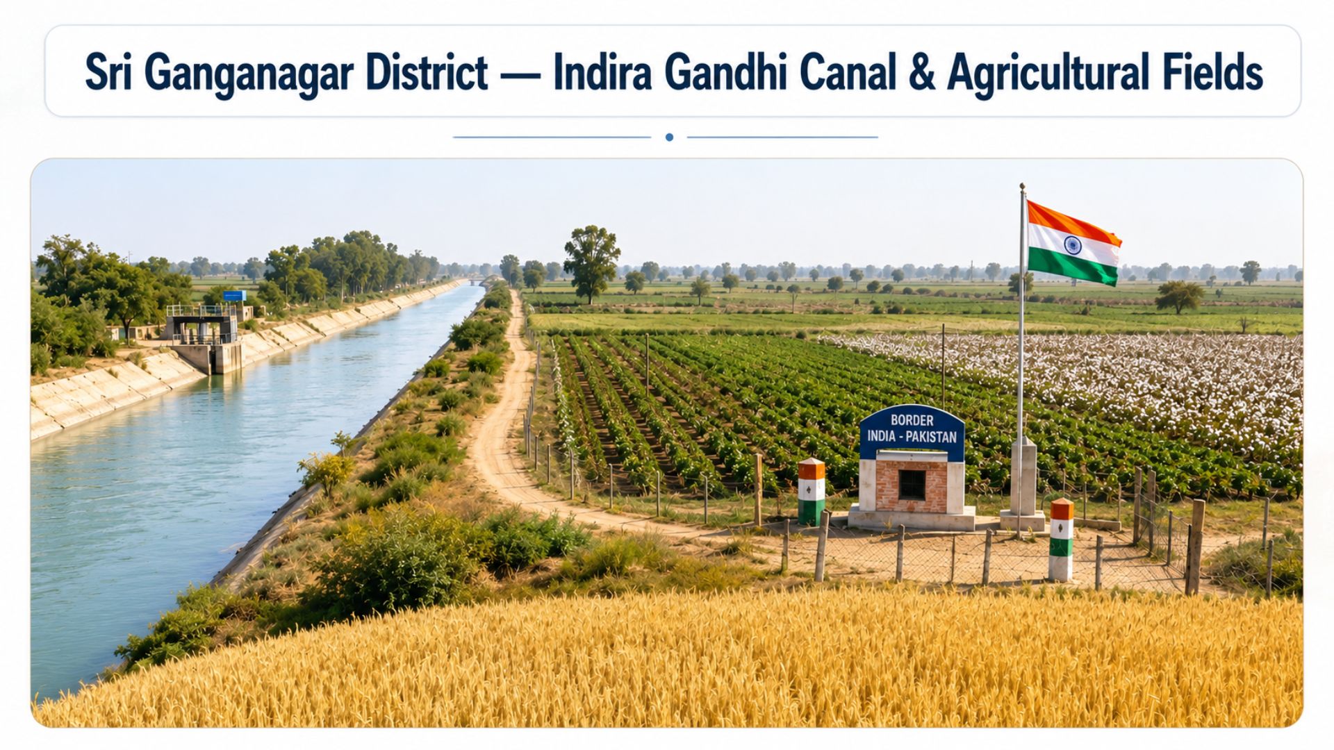
Sri Ganganagar-'Food Basket of Rajasthan
- 210 km border length with Pakistan.
- Punjab (Pakistan) - districts of Bahawalnagar and Bahawalpur, Pakistani province on the opposite side.
- Fertile agricultural plains, unlike the rest of the border, which is desert Geographical character.
- Hindumal Kot - the northernmost point of Rajasthan's Pakistan border, the northern starting point.
- Indira Gandhi Canal (formerly Rajasthan Canal) transforms this desert fringe into fertile agricultural land. Key irrigation.
- Wheat, cotton, sugarcane, and mustard are major crops.
- Hosts major military installations due to its border proximity. Strategic significance
- Pakistan's 1st Armored Division targeted the Sri Ganganagar sector during the 1971 war. Pakistan's plan in 1971
Sri Ganganagar is often called the 'Food Basket of Rajasthan' due to its exceptional agricultural productivity - a remarkable feat given that the area was once a semi-arid desert transformed by canal irrigation.
NOTE: Sri Ganganagar has Pakistan's Punjab province on its other side. Pakistani districts: Bahawalnagar, Bahawalpur, Rahimyar Khan.
Bikaner - 'Camel Country'
- 168 km (SHORTEST among the four districts) Border length with Pakistan
- Punjab (Pakistan): Pakistani province on the opposite side
- Arid Thar Desert landscape, sparse vegetation, dunes, and geographical character
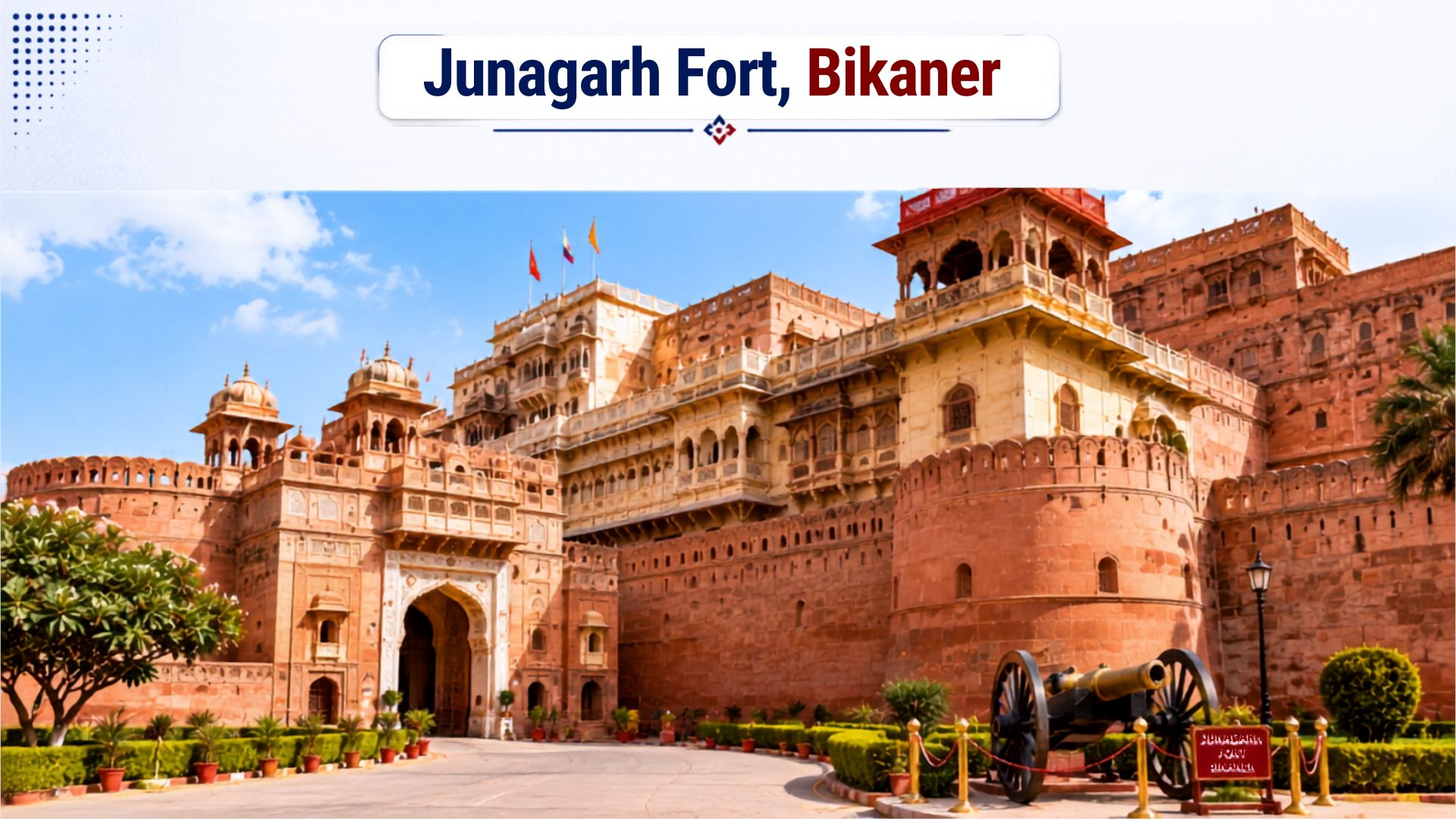
- Junagarh Fort (16th century), Karni Mata Temple (Deshnok), National Research Centre on Camel
- Bikaner State played a crucial role in both World Wars and post-independence defense. Historical importance
- Bikaner city is a major railway junction, connecting to Jodhpur, Delhi, and Jaisalmer. Connectivity
- Brick-making, leather goods, handicrafts, famous Bikaneri bhujia and sweets industries:
NOTE: Bikaner shares the SHORTEST border with Pakistan among the four districts — only 168 km. This is frequently asked in MCQs.
Jaisalmer - 'The Golden City'
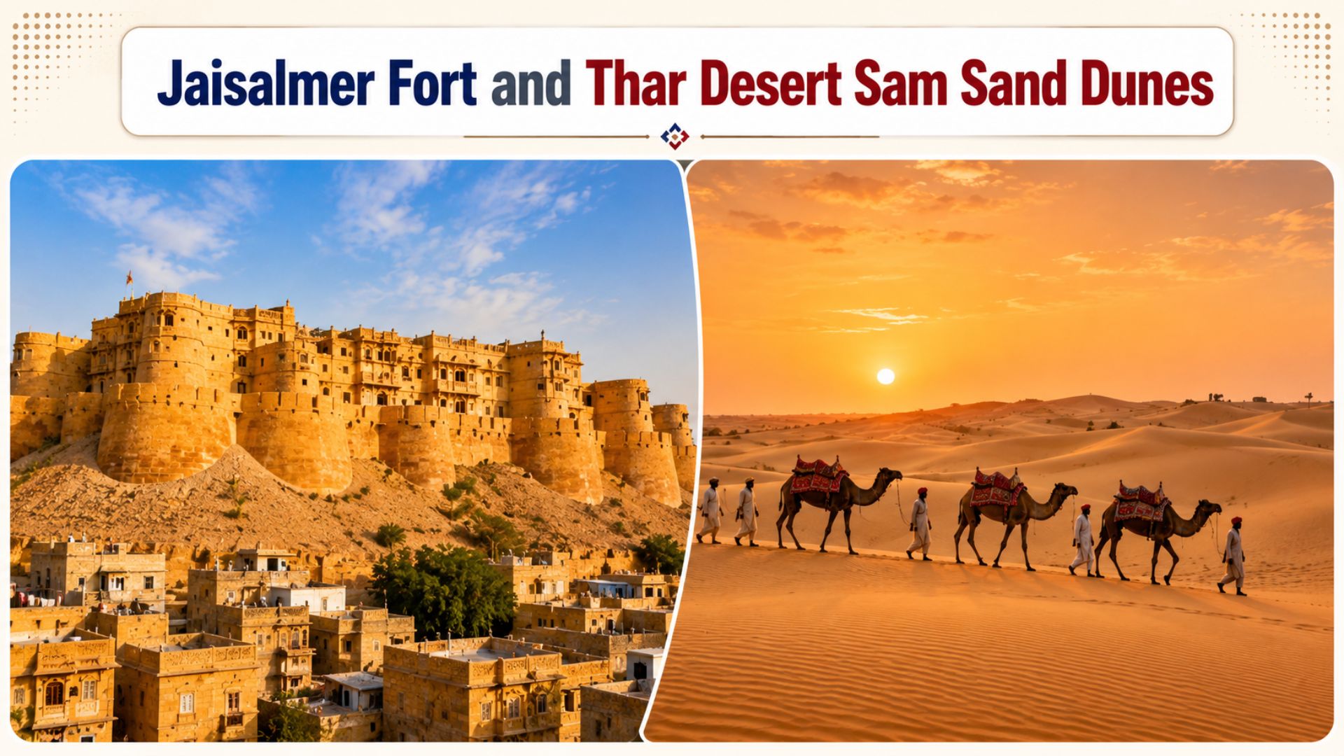
• 464 km (LONGEST among the four districts - nearly half the total border) Border length with Pakistan
• Punjab & Sindh, both Pakistani provinces on opposite sides:
• Dominated by Thar Desert; vast sand dunes; sparse vegetation; harsh climate Geographical character:
• The Golden City - due to the yellow sandstone architecture, a famous nickname
• Jaisalmer Fort (Sonar Quila), Sam Sand Dunes, Khuri Village, Tanot Mata Temple Key landmarks
• Jaisalmer Air Force Base; Longewala War Memorial; key army forward posts Military importance
• Battle of Longewala (December 4-7, 1971) - one of India's most iconic military victories. Historical battle
• Desert National Park; annual Desert Festival; camel safari; border tourism
Battle of Longewala (1971) - A Critical Sub-topic
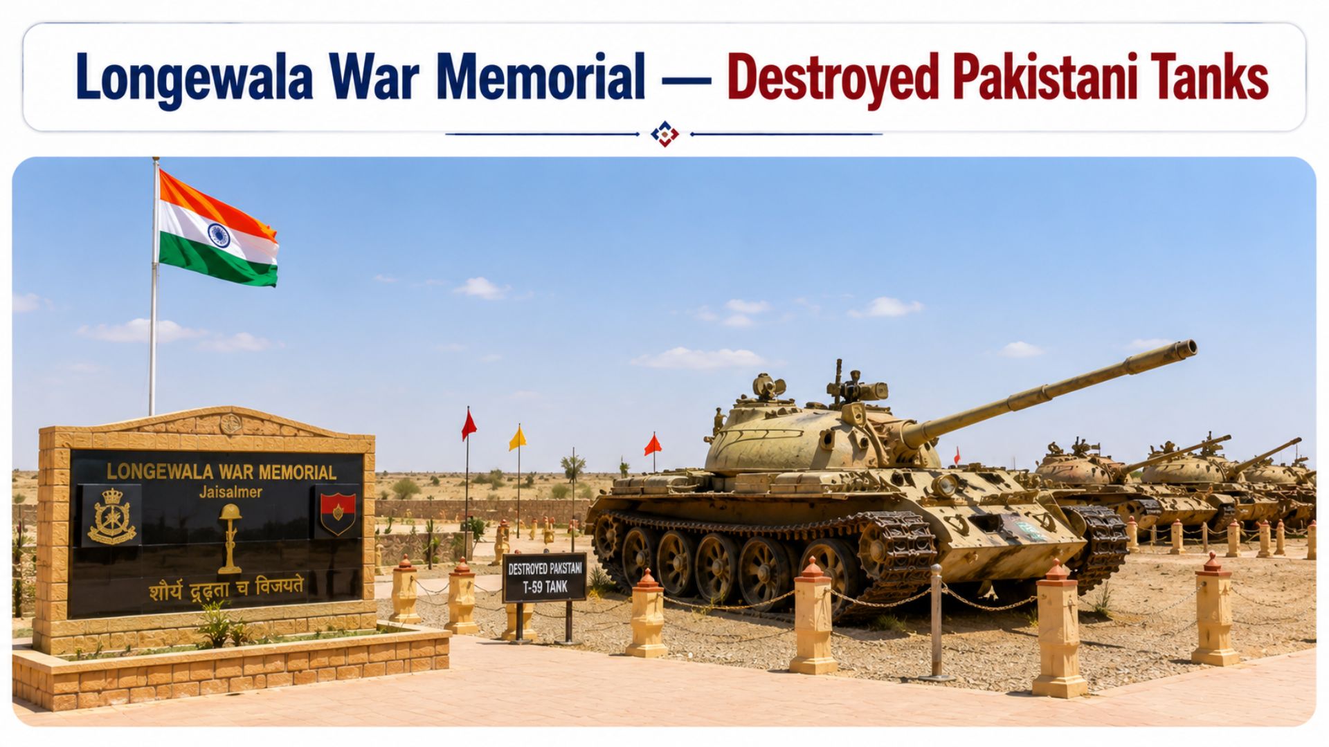
The Battle of Longewala is one of the most celebrated military engagements in Indian history. Fought between 4 and 7 December 1971 in the Thar Desert of Jaisalmer district, it is often described as India's Battle of Thermopylae.
• Longewala border post, Thar Desert, Jaisalmer district Location
• Approximately 120 soldiers of 'A' Company, 23rd Battalion, Punjab Regiment, Indian strength
• Major Kuldip Singh Chandpuri (later promoted to Brigadier; awarded Maha Vir Chakra), Commanding officer
• 2,000–3,000 soldiers with approximately 40–45 T-59 tanks; elements of the 18th Division Pakistani attacking force
• Hawker Hunter aircraft from Jaisalmer air base under Wing Commander M.S. Bawa - decisive air support, Key IAF role
• Complete Indian victory; 37+ Pakistani tanks destroyed; no significant territorial gains by Pakistan in Rajasthan Outcome
• Denied Pakistan any bargaining chip; freed Indian resources for the Eastern Front (liberation of Bangladesh). Strategic result
• Tanot Mata Temple - hundreds of Pakistani shells fell around it but failed to explode; now managed by BSF Related site
NOTE: Jaisalmer has the LONGEST border with Pakistan - 464 km. The Battle of Longewala (1971) was fought here. Major Kuldip Singh Chandpuri was awarded the Maha Vir Chakra.
Barmer - 'Land of Oil and Desert Crafts'

• 228 km border length with Pakistan:
• Sindh (Pakistan) - districts of Ghotki, Sukkur, Khairpur, Tharparkar, Umarkot (Pakistani province on the opposite side)
• Predominantly desertic; harsh climate; summer temperatures exceeding 50°C Geographical character
• Shahgarh - the southernmost point of Rajasthan's Pakistan border, the southern endpoint of the border
• Munabao (Barmer) - Khokhrapar (Pakistan) rail link - historically used by Thar Express, Key border crossing
• Significant oil and natural gas reserves - Cairn India (now Vedanta) made major discoveries here. Economic importance
• Famous for traditional embroidery, block printing, folk music, and Bhopa-Bhopi performers. Cultural significance
• Gadra Road in Barmer district - the southernmost extension of the Indira Gandhi Canal sub-branch, Zero Point of Indira Gandhi Canal
NOTE: Barmer's southern point (Shahgarh) is where Rajasthan's border with Pakistan ENDS. The Munabao–Khokhrapar rail link connects Barmer to Pakistan's Sindh province.
Pakistani Districts/Provinces Adjoining Rajasthan Border
Knowing which Pakistani provinces and districts lie across the border is a frequently tested topic in RAS. The Rajasthan border touches two Pakistani provinces
Punjab Province (Pakistan) - Opposite Sri Ganganagar and Bikaner
• Bahawalnagar district
• Bahawalpur district
• Rahimyar Khan district
Sindh Province (Pakistan) - Opposite Jaisalmer (southern part) and Barmer
• Ghotki district
• Sukkur district
• Khairpur district
• Sanghar district
• Umarkot district
• Tharparkar district
NOTE: Punjab (Pakistan) → faces Sri Ganganagar and Bikaner. Sindh (Pakistan) → faces southern Jaisalmer and Barmer. Both provinces border Rajasthan.
Indira Gandhi Canal - Strategic and Agricultural Lifeline
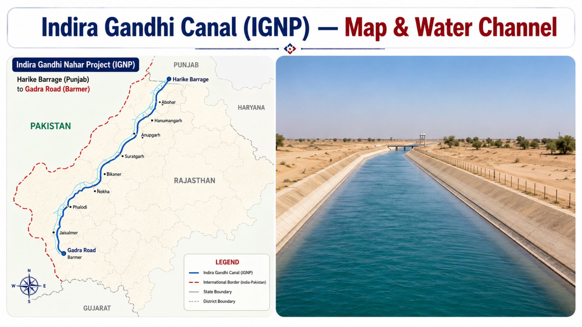
The Indira Gandhi Canal Project (IGNP), formerly known as the Rajasthan Canal, is the longest canal in India with a total length of 837 kilometers. It runs roughly parallel to the Pakistan border at an average distance of approximately 40 km, serving both agricultural and strategic purposes.
• Harike Barrage at the confluence of the Sutlej and Beas rivers in Punjab Origin
• Gadra Road (Barmer district) - the Zero Point of the canal terminus
• 445 km (from Masitawali, Hanumangarh to Mohangarh, Jaisalmer) Main canal length
• 837 km; planned network 9,060 km Total system length
• Sri Ganganagar, Hanumangarh, Bikaner, Jaisalmer, Barmer, Jodhpur, and Churu Districts benefited
• Approximately 19.63 lakh hectares Culturable command area
• Covers Ganganagar and Bikaner; 5.53 lakh hectares Stage I (completed)
• Extends to Jaisalmer and Barmer; 14.10 lakh hectares Stage II
• From 'Rajasthan Canal' to 'Indira Gandhi Canal' in 1984, after the assassination of PM Indira Gandhi. Renamed
• India used the waters of the Sutlej, Beas, and Ravi - the legal basis for this canal is the Indus Waters Treaty (1960)
• Transformed Thar Desert into agricultural land; also caused waterlogging and soil salinity in some areas Environmental impact
NOTE: The Indira Gandhi Canal flows parallel to the Pakistan border at ~40 km distance and serves a STRATEGIC purpose in addition to irrigation - important for RAS Mains answers.
Strategic and Defense Importance of the Border
Rajasthan's international border with Pakistan is one of India's most strategically sensitive frontiers. Several key elements define its defense significance
Border Security Force (BSF)
• The BSF is the primary force responsible for guarding the India-Pakistan International Border (IB) in Rajasthan
• The Indian Army guards the Line of Control (LoC) in Jammu & Kashmir - not this border
• BSF operates camel-mounted patrols in the difficult desert terrain
• The Tanot Mata Temple near the Jaisalmer border is under BSF administration
Key Military Bases and Installations
• Jaisalmer Air Force Base - Fighter aircraft station; played decisive role in 1971 war
• Barmer Air Force Station - Strategic aviation asset
• Bikaner (Nal) Air Force Base - Operational airfield
• Sri Ganganagar - Multiple army cantonments and border outposts
Smart Fencing Project
The Comprehensive Integrated Border Management System (CIBMS) - commonly called the Smart Fencing Project - is being implemented along the India-Pakistan border in Rajasthan. It uses advanced surveillance technology, including sensors, cameras, radars, and thermal imaging, to detect infiltration attempts in real time.
Border Area Development Programme (BADP)
The Border Area Development Programme (BADP) is a Central Government scheme specifically designed for the development of remote areas near the international border:
• 1993-94 (initially started in 1987 in a limited form) Launched
• 16 development blocks across Sri Ganganagar, Bikaner, Jaisalmer, and Barmer districts. Coverage in Rajasthan
• Department of Rural Development and Panchayati Raj, Rajasthan Nodal Department
• 0–40 km from the international border fence Priority zone
• Meet developmental needs of border residents; build essential infrastructure; provide social security Key objectives
• Roads, schools, health centers, drinking water, solar street lights, community centers, sanitation. Activities covered
• Fund utilization in Rajasthan ranged between 40 and 61% (2010-15); satisfaction levels among border residents remain low. Challenge
Important Border Crossings and Connectivity
Munabao – Khokhrapar Rail Link
The Munabao (Barmer, Rajasthan) to Khokhrapar (Sindh, Pakistan) rail link is the only rail connection between Rajasthan and Pakistan. The Thar Express (Jodhpur to Karachi) used this route, but service has been suspended multiple times due to India-Pakistan tensions. It is not open to foreign nationals.
Gadra Road Border Area
Located in the Barmer district, Gadra Road is a small town approximately 6 km from the India-Pakistan border. It serves as a minor crossing point and is also where the Indira Gandhi Canal sub-branch reaches its southernmost extension.
Quick Revision - MCQ Tricks and Memory Aids
1. North-to-South Memory Order
Remember the four districts from north to south using this phrase:
"Sab Gharo Bahar Jao" → Sri Ganganagar → (Bikaner) → (Barmer) → (Jaisalmer)
Correct North-to-South order: Sri Ganganagar → Bikaner → Jaisalmer → Barmer
2. Key One-Liners for MCQs
• Rajasthan's Pakistan border = 1,070 km (longest in India)
• Longest border district: Jaisalmer (464 km)
• Shortest border district: Bikaner (168 km)
• Border starts: Hindumal Kot (Ganganagar) in the north
• Border ends: Shahgarh (Barmer) in the south
• Radcliffe Line drawn by Sir Cyril Radcliffe, announced 17 August 1947
• Battle of Longewala: 4-7 December 1971, Jaisalmer; Major Kuldip Singh Chandpuri (MVC)
• Longest canal in India running parallel to the Pakistan border: Indira Gandhi Canal (837 km)
• BADP covers: 16 blocks in 4 border districts of Rajasthan
• Rail link to Pakistan: Munabao (Barmer) – Khokhrapar (Pakistan Sindh)
• BSF guards: International Border (IB); Indian Army guards: Line of Control (LoC)
• Pakistani provinces bordering Rajasthan: Punjab (NW) + Sindh (W)
Conclusion: Rajasthan Border Districts with Pakistan
Preparing this topic made me realize that these four districts are not merely dots on a map. The land of Sri Ganganagar, once a stretch of sand, now yields wheat and cotton - all thanks to the Indira Gandhi Canal. The border post at Longewala in Jaisalmer, defended by just 120 soldiers in 1971, stands today as a war memorial visited by thousands. Collectively, these four districts embody India's security, history, and developmental challenges all at once.
If you are preparing for the RAS exam, do not simply memorize the figure of 1,070 km. Understand why Jaisalmer shares the longest border, why Ganganagar is fertile despite being a border district, and what the strategic significance of the 1971 Battle of Longewala truly was. This geography is not just for an exam - it is the living story of India's western frontier. And it is this depth of understanding that distinguishes a 2-mark answer from a 10-mark Mains answer.
BEST SELLER
🏆 PRELIMS
RAS Pass
Prelims focused Hindi & English
₹399
✓
Prelims Topic-Wise Tests
✓
Subject-Wise Tests
✓
Full-Length Prelims Tests
✓
Daily Current Affairs Tests
✓
Prelims PYQs Tests
✓
Detailed Solutions & Analysis
✓
All Rajasthan Ranking
✓
Unlimited Reattempts
✓
Mains Tests
✓
Hindi & English Tests
✓
All Rajasthan Ranking
Trusted by 5,000+ Students
Post Category
- RAS Salary
- Result
- RAS Admit Card
- RAS Job
- RAS Cutoff
- Preparation Tips
- RAS Answer Key
- RAS Exam Analysis
- RAS Syllabus
- RAS Previous Year Papers
- RPSC RAS Exam Pattern
- RAS Interview
- RAS Exam Date
- RAS Vacancy
- RAS Test Series
- RAS Best Books
- RAS Preparation Resources
- RAS Coaching Centre
- History
- Polity
- Geography
- Economics
- Science
- Art and Culture
- RPSC RAS Application Form
- RPSC RAS Notification
- RAS Eligibility Criteria
- UPSC Exam
Visit Our RASonly Offline Center
Our Expert Faculty

Bhunesh Sir
Current Affairs · 13+ Yrs

Aamir Khan Sir
RAS-2017 · IIM Ahm.

Akash Sir
Polity · 8+ Yrs
Free Resources
Official Mobile App

RASOnly App
by OTSAdda · Free
Full Video Lectures
Mock Tests & PYQs
Daily Current Affairs
AI Mock Interview
Free Download · No subscription needed to install
RAS 2024 Toppers — RASonly
Rank 2
Virendra Charan
Rank 9
Bhoopinder Singh
Rank 26
Aanchal Nagpal
Rank 33
Lokendra Singh
Rank 45
Amar Rathore
Rank 46
Manasvini Verma

Join RASonly WhatsApp Community
Get daily current affairs, exam alerts, free study material and tips from expert faculty — right on WhatsApp.
Join for Free →RASonly Interview Guidance Program

Mr. Ashok Jain
Ex-Chief Secretary Govt of Rajasthan
- IAS officer of the 1981 batch, Rajasthan cadre.
- Passionate about mentoring the next generation of RAS officers with real-world insights.
- Got retired in Dec 2017 from the post of Chief Secretary of the state of Rajasthan.

Mr. Guru Charan Rai
Ex-ASP / SP in Jaisalmer
- Guru Charan Rai, IPS (Retd), retired as Inspector General of Police (Security), Rajasthan, Jaipur in 2017.
- Served as ASP and SP in Jaisalmer, Nagaur, Sri Ganganagar, Sawai Madhopur, Dausa, Sikar, and Karauli.
- He also held key positions as DIGP and IGP in the Law and Order division.

Mr. Rakesh Verma
Ex-IAS Officer, B.Tech, MBA, and M.A. (Economics)
- IAS officer of the 1981 batch and retired in Chief Secretary Rank.
- Civil servant of high repute and vast experience.
- Has been teaching UPSC CSE subjects for the last six years.
Related Post


Daily Current Affairs for RAS Exam Preparation 2026
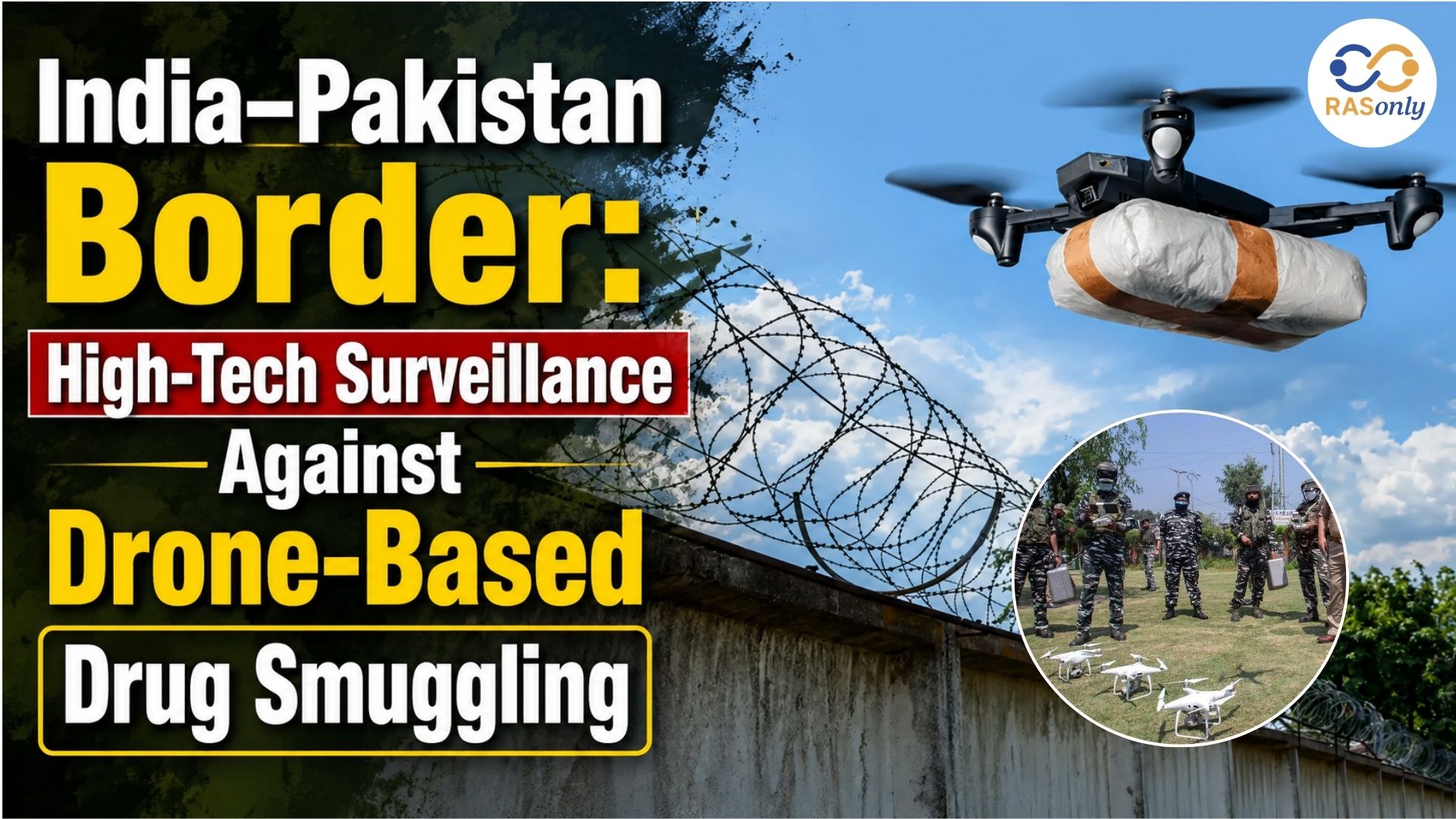
India–Pakistan Border
June 26, 2026
Makrana Marble Waste
June 26, 2026
Blue-Cheeked Bee-Eater Reaches Rajasthan
June 25, 2026