Great Boundary Fault of Rajasthan: Complete RAS Exam Notes
Great Boundary Fault of Rajasthan: Complete RAS Exam Notes

Get in Touch with RASonly!

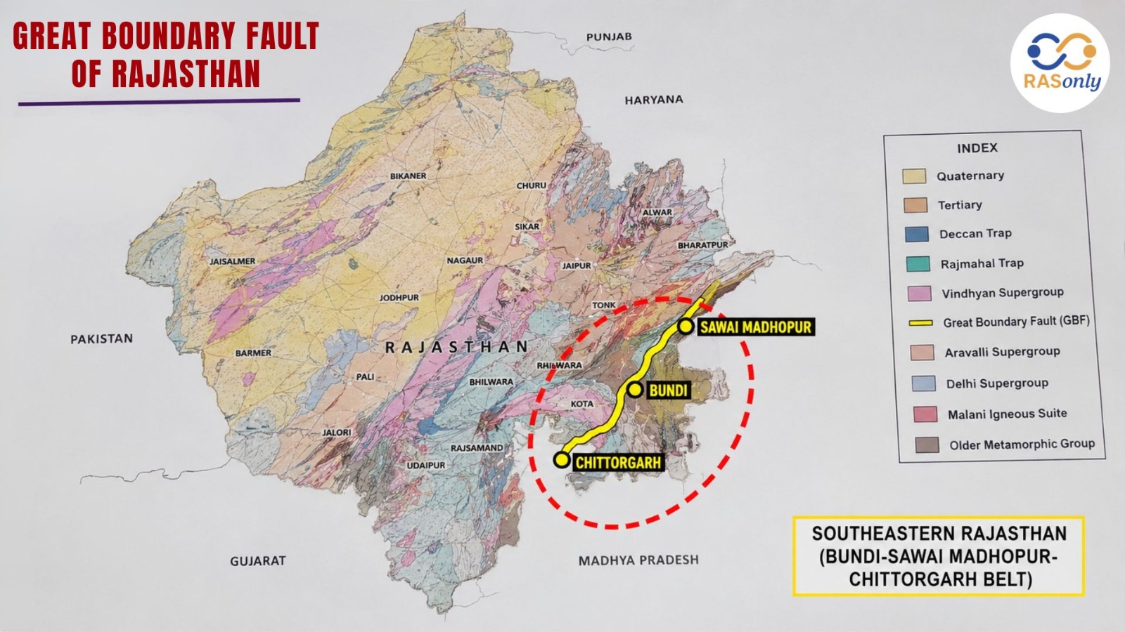
The Great Boundary Fault of Rajasthan is one of the most significant tectonic features in the state's geography, marking the boundary between the ancient Aravalli rock system and the younger Vindhyan sedimentary system. Running through southeastern Rajasthan along the Bundi–Sawai Madhopur hills, this reverse fault stretches nearly 400 km and plays a key role in shaping the region's minerals, soil, and seismic activity. For RAS aspirants, this topic is a must-know part of Rajasthan's physical geography.
If you are preparing for the RAS exam or any other Rajasthan state-level competitive exam, understanding the Great Boundary Fault of Rajasthan is essential. This geological feature is one of the most important topics under Rajasthan's physical geography, and it frequently appears in both prelims and mains papers. In this article, we will break down everything you need to know - its formation, location, significance, and exam-relevant facts - in a simple, accurate, and easy-to-remember format.
What is the Great Boundary Fault of Rajasthan?
The Great Boundary Fault (GBF) is a major tectonic lineament - essentially a large-scale reverse (thrust) fault - running through southeastern Rajasthan. It marks the boundary between the ancient Aravalli/Bhilwara rock system on one side and the younger Vindhyan sedimentary system on the other. In simple terms, it is a fracture zone in the earth's crust where rocks of very different ages and origins come into contact, and this contact zone has shaped much of southeastern Rajasthan's landscape over hundreds of millions of years.
The fault runs mainly along the Bundi–Sawai Madhopur hills, extending southward towards Chittorgarh and further up to Sawai Madhopur (Machilpur) in the north. It has a strike length of approximately 400 km, making it one of the most prominent and well-studied tectonic features in the entire Indian subcontinent.
Quick Fact Table: Great Boundary Fault at a Glance
| Feature | Details |
|---|---|
| Full Name | Great Boundary Fault (GBF) |
| Type of Fault | Reverse (thrust) fault; branching basement fault |
| Region | Southeastern Rajasthan |
| Main Alignment | Bundi–Sawai Madhopur hills |
| Approximate Length | ~400 km |
| Rock Systems Separated | Aravalli/Bhilwara Supergroup and Vindhyan Supergroup |
| Key Districts | Chittorgarh, Bundi, Sawai Madhopur (also extends towards Kota–Jhalawar/Hadoti area) |
| Age of Formation | Debated – possibly late Archean origin, reactivated before and after Vindhyan sedimentation |
| Best Exposure Site | Near Bundi (about 10 km NW on Jaipur road) and around Chittorgarh |
| Associated Rock Types | Cataclasite, mylonite, fault breccia, sheared rocks |
Formation of the Great Boundary Fault
The formation history of the Great Boundary Fault is not settled among geologists, and different scholars have proposed different theories over the years - a point that is often asked in RAS mains answers.
| Geologist | Proposed Theory |
|---|---|
| Fermor (1930) | First proposed the concept of the Great Boundary Fault as a major lineament. |
| Heron (1953) | Believed the fault developed during the uplift of the Aravalli ranges in the Mesozoic Era. |
| Pascoe (1959) | Attributed its formation to folding of the Aravalli and Delhi Groups of rocks during Precambrian time. |
| Recent Studies (Ghosh et al., 2022) | Suggested the fault likely originated in the late Archean era and formed a topographic barrier west of the Vindhyan Basin. |
What most studies agree on is this: the fault originated before the Vindhyan sediments were deposited, but it was reactivated multiple times - both during and after Vindhyan sedimentation - which explains why it shows a complex mix of both brittle and ductile deformation (that is, rocks that fractured as well as rocks that bent and flowed under pressure).
Location and Geographical Extent
The Great Boundary Fault runs mainly in a northeast to southwest direction through southeastern Rajasthan. Its extent and the districts it is most closely associated with are:
| District | Significance in Relation to GBF |
|---|---|
| Chittorgarh | One of the best and most complete exposures of the Great Boundary Fault (GBF); Vindhyan and Bhilwara Supergroup rocks are clearly visible here. |
| Bundi | The fault is classically studied here, visible as a step-like zone with deformed limestone near Satur. |
| Sawai Madhopur | Marks the northern extent of the fault (Machilpur area). |
| Kota & Jhalawar (Hadoti region) | Lie in the broader Hadoti belt influenced by the GBF's tectonic zone. |
To the west of this fault lie the Aravalli and Bhilwara rock formations. To the east lies the Vindhyan basin, known for flat-topped plateaus and sedimentary rock layers such as sandstone and limestone. This is why the GBF is often described as the natural western/northern boundary of the Vindhyan basin.
Significance of the Great Boundary Fault in Rajasthan Geography
1. Geological Boundary
It clearly separates the older Aravalli/Bhilwara rock system from the younger Vindhyan sedimentary system, making it a textbook example of a major fault-based geological boundary in India.
2. Mineral Wealth
The zone around the Great Boundary Fault is associated with valuable mineral and rock resources, including limestone, sandstone, and other deposits found in the Hadoti and Chittorgarh belt, contributing to Rajasthan's mineral-rich reputation.
3. Soil and Agriculture Impact
Because the fault separates two different rock types, the soil composition on either side varies, which affects agricultural patterns in districts like Kota, Bundi, and Chittorgarh — particularly the black soil zones associated with the Hadoti region.
4. Seismic Relevance
As a branching reverse basement fault connected to broader tectonic systems extending towards the Sub-Himalayas, the GBF zone is considered relevant to regional seismic activity, making it geologically active rather than a purely historical feature.
5. Exam Relevance
The Great Boundary Fault is a recurring topic in RAS prelims (Rajasthan GK section) and often appears as a short-answer or map-based question in mains papers, making it a high-priority, high-scoring topic.
Great Boundary Fault vs Aravalli Range: Key Differences
Many students confuse the Aravalli Range with the Great Boundary Fault. Here is a clear comparison:
| Point of Comparison | Aravalli Range | Great Boundary Fault (GBF) |
|---|---|---|
| What it is | A fold mountain range | A tectonic fault (fracture) line |
| Formation | Formed by folding and upliftment of ancient rocks | Formed by fracturing/faulting along a rock contact zone |
| Location | Runs across western and central Rajasthan (Gujarat to Delhi) | Runs through southeastern Rajasthan (Bundi–Sawai Madhopur–Chittorgarh) |
| Role | A landform/mountain system | A geological boundary between Aravalli and Vindhyan rocks |
| Length in Rajasthan | About 550 km | About 400 km |
Related Topics You Should Connect This With
RAS mains often rewards answers that link one topic to related ones. Keep these connections in mind:
- Vindhyan Basin: The GBF forms the western/northern limit of this basin; Vindhyan rocks in Rajasthan range in age from roughly 1400 to 600 million years.
- Bhilwara Supergroup (Berach Granite): The basement rock on the Aravalli side, dated to around 2500–2585 million years old - one of the oldest rock units in the region.
- Hadoti Plateau: The GBF's eastern tectonic zone strongly overlaps with the Hadoti region (Kota, Bundi, Baran, Jhalawar), so questions on Hadoti's geology often reference the GBF.
- Main Boundary Thrust (Himalayas): Occasionally used in comparative questions, since both are major reverse/thrust faults in Indian geology, though in entirely different mountain systems.
Practice Questions for Self-Assessment
These are objective-style questions based on verified facts covered above - useful for quick self-testing before moving to full mock tests.
- In which part of Rajasthan is the Great Boundary Fault located? (Answer: South-eastern Rajasthan, along the Bundi–Sawai Madhopur hills)
- The Great Boundary Fault separates which two major rock/geographic systems? (Answer: The Aravalli system and the Vindhyan/Hadoti system)
- What type of fault is the Great Boundary Fault classified as? (Answer: A reverse/thrust fault - a branching basement fault)
- Name the three districts most closely associated with the Great Boundary Fault's exposure. (Answer: Chittorgarh, Bundi, and Sawai Madhopur)
- Approximately what is the strike length of the Great Boundary Fault? (Answer: About 400 km)
Note: For official RPSC RAS previous year papers, always cross-check with RPSC's official website or verified previous year paper PDFs, since many online sources reproduce similar questions without confirming the original exam year.
Quick Revision Points for RAS Exam
- The Great Boundary Fault is a reverse (thrust) fault, not a simple fracture line.
- It separates the Aravalli/Bhilwara Supergroup from the Vindhyan Supergroup.
- Main districts: Chittorgarh, Bundi, and Sawai Madhopur; also relevant to the Hadoti region (Kota, Jhalawar).
- Strike length: approximately 400 km.
- Different theories of formation exist - Fermor, Heron, Pascoe, and modern researchers all differ on the exact timing.
- Best-studied exposure sites: near Bundi and around Chittorgarh.
- Frequently asked in both the Rajasthan geography and geology sections of RAS prelims and mains.
Conclusion
The Great Boundary Fault of Rajasthan is more than just a line on a geological map - it represents a long and still-debated history of tectonic activity that continues to influence the state's soil, minerals, and seismic character even today. For RAS aspirants, mastering this topic means going beyond memorizing facts and understanding the logical connection between geology and geography. Revise the districts it passes through, the different theories of its formation, and its significance, and you will be well-prepared to answer any question related to this topic in your exam.
FAQs - Great Boundary Fault of Rajasthan
It is a major reverse (thrust) fault in southeastern Rajasthan that separates the Aravalli rock system from the Vindhyan sedimentary system. It runs mainly along the Bundi–Sawai Madhopur hills.
It mainly passes through Chittorgarh, Bundi, and Sawai Madhopur. It is also closely linked to the Hadoti region, including Kota and Jhalawar.
The fault has a strike length of approximately 400 km. This makes it one of the longest and most studied tectonic lines in India.
It separates the older Aravalli/Bhilwara Supergroup from the younger Vindhyan Supergroup. This contact zone reflects hundreds of millions of years of geological history.
It is a high-priority topic in Rajasthan's physical geography and geology sections. It frequently appears in both RAS prelims and mains papers.
BEST SELLER
🏆 PRELIMS
RAS Pass
Prelims focused Hindi & English
₹399
✓
Prelims Topic-Wise Tests
✓
Subject-Wise Tests
✓
Full-Length Prelims Tests
✓
Daily Current Affairs Tests
✓
Prelims PYQs Tests
✓
Detailed Solutions & Analysis
✓
All Rajasthan Ranking
✓
Unlimited Reattempts
✓
Mains Tests
✓
Hindi & English Tests
✓
All Rajasthan Ranking
Trusted by 5,000+ Students
Post Category
- RAS Salary
- Result
- RAS Admit Card
- RAS Job
- RAS Cutoff
- Preparation Tips
- RAS Answer Key
- RAS Exam Analysis
- RAS Syllabus
- RAS Previous Year Papers
- RPSC RAS Exam Pattern
- RAS Interview
- RAS Exam Date
- RAS Vacancy
- RAS Test Series
- RAS Best Books
- RAS Preparation Resources
- RAS Coaching Centre
- History
- Polity
- Geography
- Economics
- Science
- Art and Culture
- RPSC RAS Application Form
- RPSC RAS Notification
- RAS Eligibility Criteria
- UPSC Exam
- RPSC RAS Mains
Visit Our RASonly Offline Center
Our Expert Faculty

Bhunesh Sir
Current Affairs · 13+ Yrs

Aamir Khan Sir
RAS-2017 · IIM Ahm.

Akash Sir
Polity · 8+ Yrs
Free Resources
Official Mobile App

RASOnly App
by OTSAdda · Free
Full Video Lectures
Mock Tests & PYQs
Daily Current Affairs
AI Mock Interview
Free Download · No subscription needed to install
RAS 2024 Toppers — RASonly
Rank 2
Virendra Charan
Rank 9
Bhoopinder Singh
Rank 26
Aanchal Nagpal
Rank 33
Lokendra Singh
Rank 45
Amar Rathore
Rank 46
Manasvini Verma

Join RASonly WhatsApp Community
Get daily current affairs, exam alerts, free study material and tips from expert faculty — right on WhatsApp.
Join for Free →RASonly Interview Guidance Program

Mr. Ashok Jain
Ex-Chief Secretary Govt of Rajasthan
- IAS officer of the 1981 batch, Rajasthan cadre.
- Passionate about mentoring the next generation of RAS officers with real-world insights.
- Got retired in Dec 2017 from the post of Chief Secretary of the state of Rajasthan.

Mr. Guru Charan Rai
Ex-ASP / SP in Jaisalmer
- Guru Charan Rai, IPS (Retd), retired as Inspector General of Police (Security), Rajasthan, Jaipur in 2017.
- Served as ASP and SP in Jaisalmer, Nagaur, Sri Ganganagar, Sawai Madhopur, Dausa, Sikar, and Karauli.
- He also held key positions as DIGP and IGP in the Law and Order division.

Mr. Rakesh Verma
Ex-IAS Officer, B.Tech, MBA, and M.A. (Economics)
- IAS officer of the 1981 batch and retired in Chief Secretary Rank.
- Civil servant of high repute and vast experience.
- Has been teaching UPSC CSE subjects for the last six years.
Related Post


Daily Current Affairs for RAS Exam Preparation 2026

Pokaran Green Drive 2026
July 03, 2026
Rajasthan Airport Projects 2026: Key Updates & Progress
July 03, 2026
Rajasthan Solar Energy Power Bank
June 30, 2026