RAS Mains Essay Topics 2026: Most Expected Topics for December Exam
National Highways & Major Transport Corridors

Get in Touch with RASonly!

National Highways in India form the backbone of the country’s road transport system, connecting major cities, ports, industrial hubs, and remote regions. Managed mainly by the NHAI, these highways—spanning over 1.44–1.46 lakh km across nearly 599 routes—carry about 40% of India’s total road traffic despite forming only 2–3% of the total road network. Key highways like NH 44, NH 27, NH 48, and NH 66 are crucial for trade, logistics, regional development, defence movement, and economic integration. State-wise networks such as those in Uttar Pradesh, Rajasthan, Maharashtra, and Tamil Nadu further strengthen connectivity and support industrial growth. National highways reduce travel time, promote tourism, enable faster freight movement, and play a vital role in balanced regional development, making them essential for India’s growth and national integration.


We say "national highways" or "major transport corridors" when we are referring to the major highways of road connectivity that cut across regions, states and sometimes the overall length or breadth of a country. In India, the National Highways system is the support system of overland transport, freight transportation, regionalization and integration of the economy. Her highways - together with strategically designed transport corridors and expressways - play a major role in mobility, trade, regional development and national integration.
In its very essence, the network of national highways is used to connect major cities, ports, and industrial centers with each other and remote regions with each other, helping to move people and goods, which, in most cases, have a large distance and go beyond state borders. Besides the highways, the major transport corridors may also have well-planned expressways, economic or freight corridors and other long-distance, high-capacity transport routes that facilitate the movement of a lot of traffic efficiently.
What is the National Highways network in India?
- The national highway network of India is a vast network of roads that are maintained by the central agencies and are supervised by the National Highways Authority of India (NHAI).
- According to the recent statistics, the country has approximately 599 national highways, which span a distance of more than ~144,000 km–146,000 km.
- The proportion of national highways in the total road network in India is only a small percentage (around 2 - 3%), although they bear an uncommonly large portion of road traffic - an estimated 40% of the total road traffic.
- The National Highway 44 (NH 44) is the longest national highway existing in the country which connects the northern end of India (Srinagar) to the southernmost (Kanyakumari), spanning a distance of approximately 4,113km.
- The shortest highways, on the other hand, can be significantly shorter (in certain cases a few kilometers) and can be a connector or link road.
The national highway system is currently the main connective tissue of the Indian overland mobility and logistics system.
Importance of National Highways in India
1. Connectivity & Accessibility
The national highways connect the major metropolitan cities, smaller towns, rural areas, ports and industrial centres and border states. They efficiently reduce distances and they are used to bridge places that would have taken a long time to travel between. This enhanced connectivity exposes opportunities to markets, education, healthcare and socio-economic people in remote or underdeveloped locations.
Those in many of the rural and semi-urban areas will be linked through a national highway resulting in access to improved goods and services, as well as an opportunity to be a part of the national economy.
2. Economic Growth, Trade, and Logistics
National highways are important in trade, industry supply and distribution as well as agriculture and trade. More rapid and efficient road transport lowers the cost and time of logistics hence it is advantageous to the manufacturers, traders, farmers and consumers. This efficiency is extremely important in transportation of goods - raw materials to factories or finished products to markets - particularly when time and perishable goods are to be considered.
The industrial development in the region is fostered by corridors and highways which make it possible to have the industries located outside the overcrowded urban centres yet well connected. They also establish ports and centers of production - which is very important in exports and inter-state trade.
3. Regional Integration and Balanced Development
Highway facilitates integration of the country by connecting remote areas via good road networks. They also assist in diminishing the regional inequalities as the backward regions are given the enhanced access and mobility. This has made development to not be limited to big cities or a select few states.
Greater connectivity tends to promote the gathering of ancillary infrastructure - industrial estates, logistic centres, warehousing, small towns - in effect jump-starting economic activity in hitherto isolated areas.
4. Strategic & Administrative Importance
There is also strategic significance of national highways. They play a very important role in defence logistics, disaster response and emergency services - enabling swift mobility across states and far-flung areas. Maintenance and development of such strategic corridors is done through the central government through agencies such as NHAI (in sensitive areas at times National Highways and Infrastructure Development Corporation Limited, NHIDCL).
Besides, enhanced road network can facilitate tourism, cultural exchange, in-country migration and general social mobility.
Major National Highways in India
India has thousands of kilometers of highways connecting every corner of the country. Here is a look at some of the major highways:
National Highway 44 (NH 44)
- Which is the longest National Highway in India? It is NH 44.
- This highway connects Srinagar in the north to Kanyakumari in the south.
- It spans over 4,000 kilometers, making it the Longest National Highway in India.
National Highway 27 (NH 27)
- NH 27 is one of the Important National Highways in India.
- It runs across eastern and western regions, covering major states like Gujarat and Assam.
National Highway 48 (NH 48)
- Known as the Best National Highway in India for its infrastructure.
- It connects Delhi to Chennai, running through major cities like Jaipur, Mumbai, and Bengaluru.
National Highway 66 (NH 66)
- Previously known as NH 17, it runs along the western coast.
- It connects Maharashtra, Goa, Karnataka, and Kerala.
National Highway 19 (NH 19)
- It is part of the historic Grand Trunk Road.
- This highway connects Delhi with Kolkata and passes through Uttar Pradesh and Bihar.
List of Important National Highways in India
National Highways in India connect cities and states, forming the backbone of transportation. For National Highways in India UPSC, understanding the List of Important National Highways in India helps aspirants grasp their routes, importance, and impact on development.
| National Highway (NH) | Route | Length (km) | Importance |
|---|---|---|---|
| NH 44 | Srinagar to Kanyakumari | 4,112 | The longest National Highway in India connects the northernmost and southernmost parts of the country. |
| NH 27 | Gujarat to Assam | 3,507 | Crucial east-west corridor, facilitates trade and connectivity across states in the north and east. |
| NH 48 | Delhi to Chennai | 2,807 | Links major cities like Delhi, Jaipur, Ahmedabad, Mumbai, and Chennai, boosting trade and tourism. |
| NH 66 | Mumbai to Kanyakumari | 1,622 | Vital for coastal connectivity, supporting trade and tourism in western and southern India. |
| NH 19 | Delhi to Kolkata | 1,465 | Part of the historic Grand Trunk Road, connects important industrial and commercial hubs. |
| NH 16 | Kolkata to Chennai | 1,533 | Links eastern ports, aiding in trade and improving logistics for imports and exports. |
| NH 75 | Gwalior to Ranchi | 650 | Supports connectivity in central and eastern India, enhancing access to remote areas. |
| NH 1 | Delhi to Amritsar | 456 | Important for defense movement and trade in Punjab and northern regions. |
| NH 548 | Kalamboli to JNPT, Maharashtra | 5 | The shortest National Highway in India serves the port of Jawaharlal Nehru Port Trust. |
| NH 8 | Delhi to Mumbai | 1,428 | Links political and financial capitals of India, facilitating trade, business, and tourism. |
| NH 125 | Almora to Tanakpur, Uttarakhand | 200 | Promotes tourism and accessibility in the Himalayan region. |
| NH 17 | Edappally (Kerala) to Panvel (Maharashtra) | 1,269 | Runs parallel to the western coastline, supporting regional connectivity and coastal trade. |
Read More: RIICO’s Land Demand for Industrial Corridors in Rajasthan
State-Wise National Highways Length
State-wise The National Highways' length highlights the distribution of India's vast road network. For National Highways in India UPSC, understanding highway lengths by state aids in analyzing regional connectivity and infrastructure development.
State-Wise National Highways Length in Tabular Form with Details
| State/UT | Total National Highways Length (km) | Key Highways | Details |
|---|---|---|---|
| Uttar Pradesh | 8,711 | NH 19, NH 44, NH 27 | Largest network; connects major cities like Varanasi, Agra, and Lucknow. |
| Rajasthan | 7,906 | NH 48, NH 27, NH 62 | Links Jaipur, Jodhpur, and Udaipur; critical for tourism and trade. |
| Maharashtra | 7,334 | NH 66, NH 48, NH 61 | Connects Mumbai, Pune, and Nagpur; essential for industrial connectivity. |
| Madhya Pradesh | 7,056 | NH 44, NH 46, NH 52 | Central connectivity; links Bhopal, Indore, and Gwalior. |
| Karnataka | 6,393 | NH 66, NH 48, NH 275 | Boosts coastal and urban connectivity, linking Bengaluru, Mangalore, and Mysuru. |
| Gujarat | 5,282 | NH 27, NH 48, NH 151 | Major trade routes connecting Ahmedabad, Surat, and ports like Kandla. |
| Tamil Nadu | 5,006 | NH 44, NH 48, NH 32 | Links Chennai, Coimbatore, and Madurai; facilitates industrial growth. |
| Andhra Pradesh | 4,910 | NH 16, NH 44, NH 65 | Connects ports and cities like Visakhapatnam, Vijayawada, and Tirupati. |
| Punjab | 3,673 | NH 44, NH 1, NH 54 | Important for defense and trade; connects Amritsar, Ludhiana, and Chandigarh. |
| West Bengal | 3,361 | NH 16, NH 19, NH 34 | Vital for eastern India’s connectivity; links Kolkata and Siliguri. |
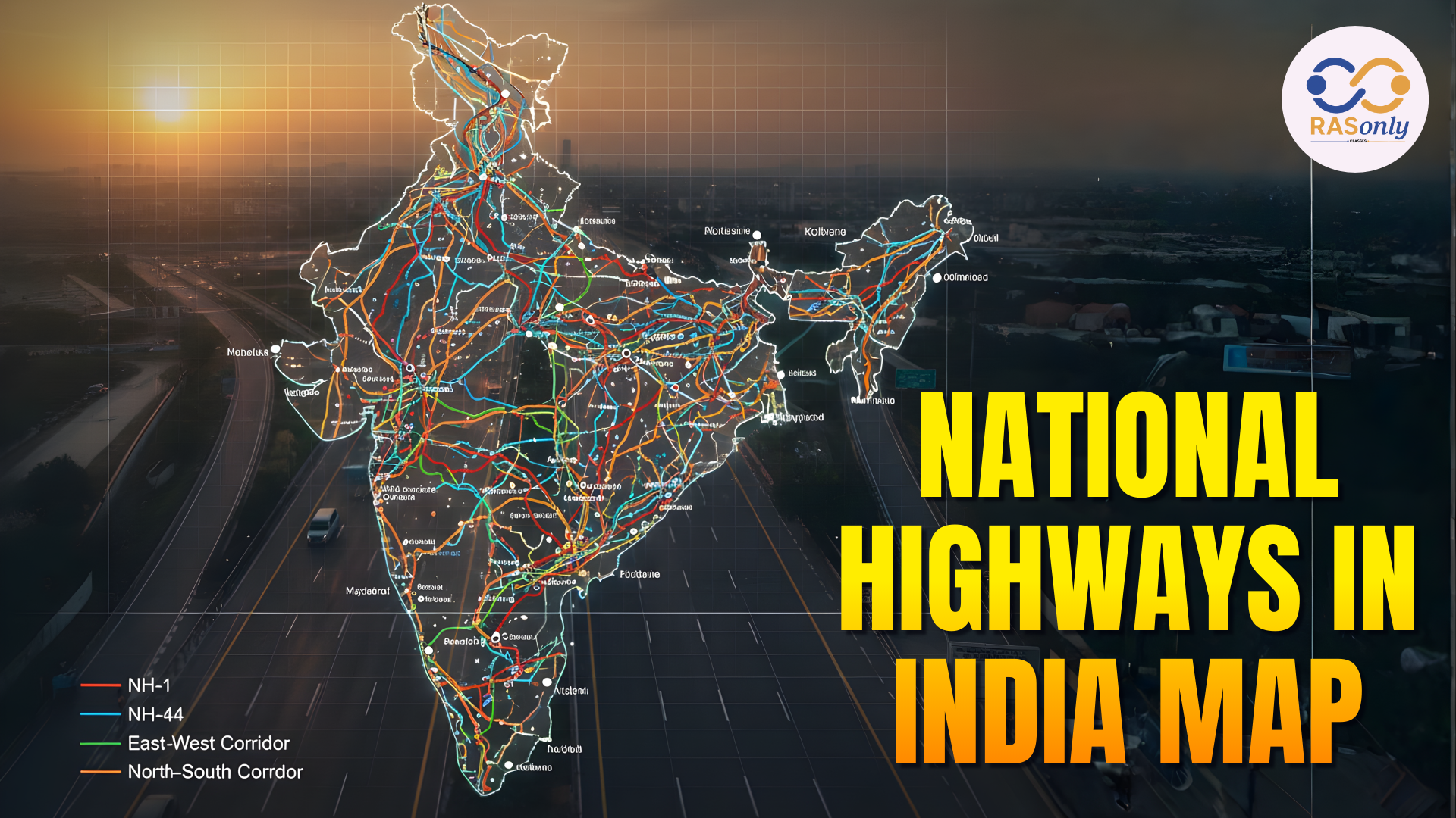
National Highways in India Map
The road transportation network in India is mainly based on the National Highways, which link major industrial centers, towns and cities in the country over long distances. These well-kept roads cover thousands of kilometers and provide an efficient flow of goods and people, which strengthens the entire infrastructure of India and, therefore, helps India to grow.
National Highways form major routes in the Indian road network and they play a crucial role in causing social integration in the country and are also essential in minimizing travelling time, transport expenses, and fuel. They will play a vital role in the development of the country and will demonstrate the interest of the government in improving the state of connectivity and access for everyone. The National Highways in India on Map is given below.
Conclusion
Highways and major transport corridors within the country provide the way in which people, goods and services are transported within the country. They bridge the separation between remote areas, make markets more accessible, minimize the time spent on traveling and make industries expand in areas other than overcrowded towns. The corridors promote trade, tourism and movement around the borders and other rural areas by connecting the cities, ports, rural areas and border regions to the rest of the economy.
With India carrying on the process of Road network expansion and modernization, the need will be to have safer, faster and efficient transport. Good highways that have been well maintained, better logistics planning and enhanced last-mile connections can make sure that growth is extended into all regions. These corridors become more than infrastructure when they are planned in a responsible manner and constructed to ensure that they are sustainable and, in doing so, become drivers of national change and integration.
BEST SELLER
🏆 PRELIMS
RAS Pass
Prelims focused Hindi & English
₹399
✓
Prelims Topic-Wise Tests
✓
Subject-Wise Tests
✓
Full-Length Prelims Tests
✓
Daily Current Affairs Tests
✓
Prelims PYQs Tests
✓
Detailed Solutions & Analysis
✓
All Rajasthan Ranking
✓
Unlimited Reattempts
✓
Mains Tests
✓
Hindi & English Tests
✓
All Rajasthan Ranking
Trusted by 5,000+ Students

Post Category
- RAS Salary
- Result
- RAS Admit Card
- RAS Job
- RAS Cutoff
- Preparation Tips
- RAS Answer Key
- RAS Exam Analysis
- RAS Syllabus
- RAS Previous Year Papers
- RPSC RAS Exam Pattern
- RAS Interview
- RAS Exam Date
- RAS Vacancy
- RAS Test Series
- RAS Best Books
- RAS Preparation Resources
- RAS Coaching Centre
- History
- Polity
- Geography
- Economics
- Science
- Art and Culture
- RPSC RAS Application Form
- RPSC RAS Notification
- RAS Eligibility Criteria
- UPSC Exam
- RPSC RAS Mains
Visit Our RASonly Offline Center

Our Expert Faculty

Bhunesh Sir
Current Affairs · 13+ Yrs

Aamir Khan Sir
RAS-2017 · IIM Ahm.

Akash Sir
Polity · 8+ Yrs
Free Resources
Official Mobile App

RASOnly App
by OTSAdda · Free
Full Video Lectures
Mock Tests & PYQs
Daily Current Affairs
AI Mock Interview
Free Download · No subscription needed to install
RAS 2024 Toppers — RASonly
Rank 2
Virendra Charan
Rank 9
Bhoopinder Singh
Rank 26
Aanchal Nagpal
Rank 33
Lokendra Singh
Rank 45
Amar Rathore
Rank 46
Manasvini Verma

Join RASonly WhatsApp Community
Get daily current affairs, exam alerts, free study material and tips from expert faculty — right on WhatsApp.
Join for Free →RASonly Interview Guidance Program

Mr. Ashok Jain
Ex-Chief Secretary Govt of Rajasthan
- IAS officer of the 1981 batch, Rajasthan cadre.
- Passionate about mentoring the next generation of RAS officers with real-world insights.
- Got retired in Dec 2017 from the post of Chief Secretary of the state of Rajasthan.

Mr. Guru Charan Rai
Ex-ASP / SP in Jaisalmer
- Guru Charan Rai, IPS (Retd), retired as Inspector General of Police (Security), Rajasthan, Jaipur in 2017.
- Served as ASP and SP in Jaisalmer, Nagaur, Sri Ganganagar, Sawai Madhopur, Dausa, Sikar, and Karauli.
- He also held key positions as DIGP and IGP in the Law and Order division.

Mr. Rakesh Verma
Ex-IAS Officer, B.Tech, MBA, and M.A. (Economics)
- IAS officer of the 1981 batch and retired in Chief Secretary Rank.
- Civil servant of high repute and vast experience.
- Has been teaching UPSC CSE subjects for the last six years.
Related Post


Daily Current Affairs for RAS Exam Preparation 2026

Bharat Taxi Expands Beyond Jaipur
July 17, 2026
Operation Clean Along India-Pakistan Border
July 17, 2026