Free Rajasthan GK One-Liner Notes for RAS
Aravalli Range: Origin, Extent and Significance

Get in Touch with RASonly!

Aravalli Range: Stretching across Rajasthan like an ancient stone spine, the Aravalli Range is one of the oldest fold mountains on Earth, older than the Himalayas themselves. Formed nearly 2,500 million years ago during the Precambrian era, it splits the state into two worlds: the parched Thar Desert in the west and the fertile plains in the east. For RAS and RPSC aspirants, this range isn't just geography-it's the key to understanding Rajasthan's climate, rivers, minerals, and history.

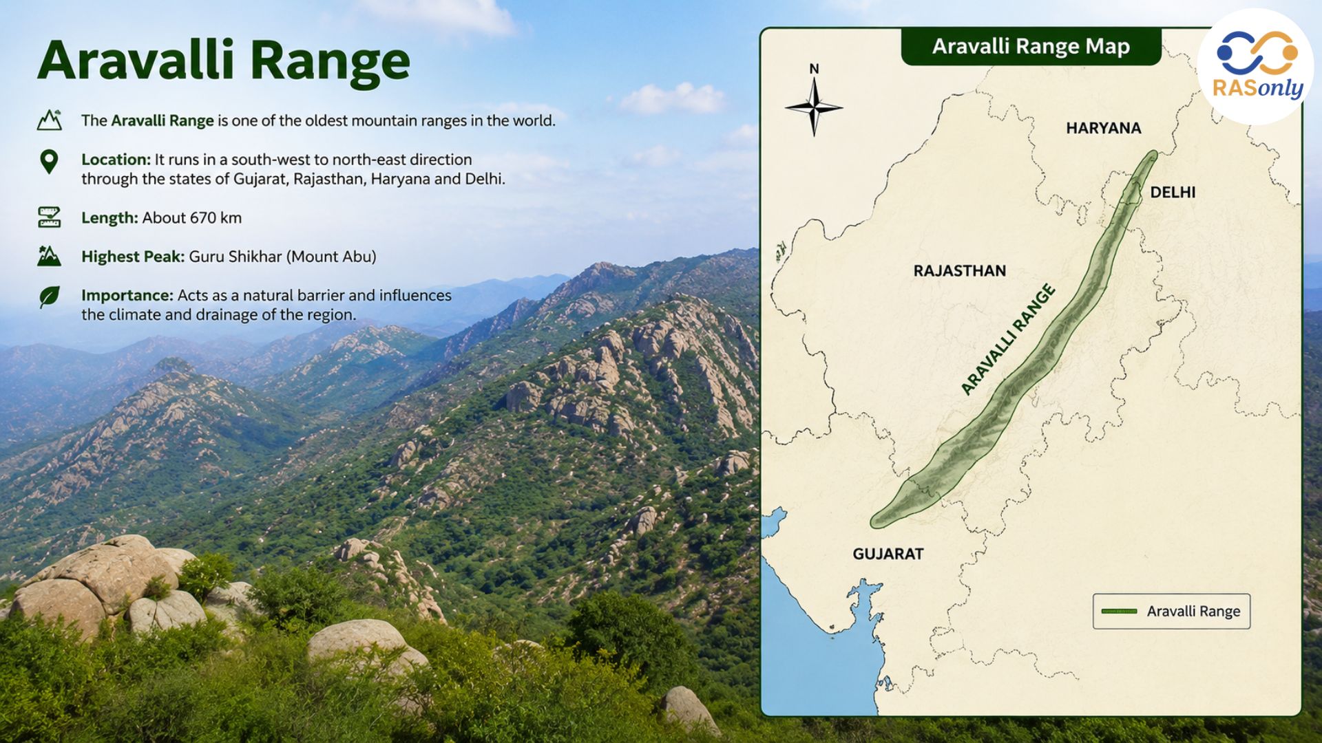
The Aravalli Range is one of the oldest fold mountain systems in the world and forms the most important physiographic feature of Rajasthan. Stretching across four Indian states, this ancient mountain range divides Rajasthan into two distinct geographical regions and plays a critical role in shaping the state's climate, drainage, and ecology. For any RAS or RPSC aspirant, understanding the Aravalli Range is essential, as it forms the foundation for almost every other topic in Rajasthan's physical geography.
What is the Aravalli Range?
The Aravalli Range is a chain of hills that runs in a north-east to south-west direction across northern and western India. It is considered one of the oldest fold mountain ranges in the world, older even than the Himalayas. In Rajasthan, the Aravalli Range acts as a natural backbone, separating the arid western desert from the fertile eastern plains.
Origin of Aravalli Range
The origin of the Aravalli Range dates back to the Precambrian era, making it one of the oldest geological formations on Earth.
- The Aravalli Range was formed due to intense folding and tectonic movements during the Aravalli-Delhi orogeny, one of the earliest mountain-building events in geological history.
- Geologists estimate the age of the Aravalli Range to be around 1,800 to 2,500 million years old.
- Due to prolonged weathering and erosion over millions of years, the range has lost its original height and now exists mostly as a series of low, rounded, and broken hills rather than tall, sharp peaks like younger mountain ranges.
- The rocks of the Aravalli system mainly consist of quartzite, schist, gneiss, and marble, which indicates their metamorphic origin.
- Because of its extreme age, the Aravalli Range is often called a "relict mountain" or a mountain in its old age stage of the geographical cycle.
Extent of Aravalli Range
The Aravalli Range has a vast geographical spread across northern and western India.
| Feature | Details |
|---|---|
| Total Length | Approximately 692–800 km |
| Starting Point | Near Champaner (Gujarat) |
| Ending Point | Near Delhi (Raisina Hills) |
| States Covered | Gujarat, Rajasthan, Haryana, Delhi |
| Extent in Rajasthan | Khedbrahma (Sirohi) to Khetri (Jhunjhunu) |
| Length in Rajasthan | Around 550 km |
| Highest Peak | Guru Shikhar (Mount Abu) – 1,722 metres |
| Average Width | 6 km to 100 km (widest near Mount Abu) |
- In Rajasthan, the Aravalli Range enters from Sirohi district near Khedbrahma and continues in a north-easterly direction, finally fading out near Khetri in Jhunjhunu district.
- The width of the range is not uniform - it is widest around Mount Abu and becomes narrower as it moves towards Delhi.
- The range gradually decreases in height from south to north, with isolated hillocks visible near Delhi.
Division of Rajasthan by Aravalli Range
One of the most important functions of the Aravalli Range is dividing Rajasthan into two major physiographic regions:
- Western Region – Covers the Thar Desert, characterized by arid climate, sand dunes, and scanty rainfall.
- Eastern Region – Covers the fertile plains and plateau areas, receiving comparatively higher rainfall and supporting agriculture.
This division has a direct impact on the climate, vegetation, agriculture, and population distribution of the entire state.
Significance of Aravalli Range
The Aravalli Range holds immense geographical, ecological, and economic importance for Rajasthan and the surrounding region.
1. Climatic Significance
- Acts as a climatic divide, blocking monsoon winds and influencing rainfall patterns differently on either side.
- Prevents the eastward expansion of the Thar Desert to a large extent.
2. Water Divide
- The Aravalli Range functions as a major water divide, separating rivers that flow towards the Arabian Sea from those flowing towards the Bay of Bengal basin.
- Rivers like Banas, Berach, and Sabarmati originate from different parts of this range.
3. Ecological Significance
- Home to important wildlife sanctuaries and forest cover, including Sariska and parts of Mount Abu Wildlife Sanctuary.
- Supports unique flora and fauna adapted to rocky and semi-arid conditions.
4. Mineral Wealth
- Rich in minerals such as copper, zinc, marble, granite, and mica.
- The Khetri copper belt, located at the northern end of the range, is a major mining hub of India.
5. Agricultural and Economic Importance
- The hills influence the fertility of adjoining plains through weathering and soil deposition.
- Acts as a natural barrier that protects eastern agricultural lands from desert winds.
6. Defence and Strategic Importance
- Historically, the Aravalli hills served as a natural defence system for Rajput kingdoms, protecting forts like Chittorgarh, Kumbhalgarh, and Ranthambore.
Quick Revision Table: Aravalli Range at a Glance
| Point | Details |
|---|---|
| Type | Fold Mountain (Oldest in the World) |
| Era of Formation | Precambrian |
| Age | 1,800–2,500 million years |
| Length | 692–800 km (India), ~550 km (Rajasthan) |
| Direction | North-East to South-West |
| Highest Peak | Guru Shikhar (1,722 m), Mount Abu |
| Rock Type | Quartzite, Schist, Gneiss, Marble |
| States Covered | Gujarat, Rajasthan, Haryana, Delhi |
| Rajasthan Extent | Khedbrahma to Khetri |
| Key Function | Divides Rajasthan into Desert and Plain Regions |
Important Points for RAS Mains
- The Aravalli Range is a textbook example of residual mountains, formed by prolonged denudation of an older, taller mountain system.
- It represents the final stage of the geographical cycle of erosion, often compared to old-age topography.
- Aspirants should be able to explain both origin (geological) and significance (functional) aspects for descriptive answers.
- Comparative questions often ask about the Aravalli vs Himalayas in terms of age and formation - remember, the Aravalli is older but structurally weaker due to erosion.
Conclusion
The Aravalli Range is far more than just a mountain system - it is the geographical backbone of Rajasthan that has shaped the state's climate, economy, culture, and history for millions of years. From its ancient Precambrian origin to its role as a modern-day water divide and mineral belt, the Aravalli Range remains one of the most important and frequently asked topics in RAS and RPSC examinations. A clear understanding of its origin, extent, and significance will help aspirants confidently tackle both prelims and mains-level questions.
Frequently Asked Questions (FAQs)
The Aravalli Range is one of the oldest fold mountain systems in the world, running from north-east to south-west across Delhi, Haryana, Rajasthan, and Gujarat. It acts as a natural divide between the arid Thar Desert and the fertile eastern plains of Rajasthan.
The Aravalli Range dates back to the Precambrian era and is estimated to be around 1,800 to 2,500 million years old, making it older than the Himalayas.
The Aravalli Range extends for approximately 692–800 km, starting near Champaner in Gujarat and ending near Delhi (Raisina Hills). Within Rajasthan, it stretches around 550 km, from Khedbrahma to Khetri.
Guru Shikhar, located near Mount Abu in Sirohi district, is the highest peak of the Aravalli Range, standing at 1,722 metres above sea level.
The Aravalli Range passes through four Indian states — Gujarat, Rajasthan, Haryana, and Delhi.
The Aravalli Range divides Rajasthan into two physiographic regions — the western Thar Desert and the eastern fertile plains. It also acts as a climatic barrier, a major water divide, a source of minerals, and a habitat for diverse wildlife.
The Aravalli Range mainly consists of quartzite, schist, gneiss, and marble, indicating its metamorphic geological origin.
The Aravalli Range blocks monsoon winds and slows the eastward expansion of the Thar Desert, directly influencing rainfall distribution and climatic conditions across the state.
Major rivers originating from the Aravalli Range include the Banas, Berach, and Sabarmati, which flow towards different drainage basins.
Due to millions of years of weathering and erosion, the Aravalli Range has lost its original height and now exists as low, rounded hills — a stage referred to as the "old age" of the geographical cycle, hence the term "relict mountain."
Yes. The Aravalli Range formed during the Precambrian era, making it significantly older than the Himalayas, which formed much later during the Tertiary period.
The Aravalli Range is a foundational topic in Rajasthan Geography, frequently asked in both RAS Prelims (factual questions on peaks, length, states) and Mains (analytical questions on its role in shaping Rajasthan's physiography and climate).

BEST SELLER
🏆 PRELIMS
RAS Pass
Prelims focused Hindi & English
₹399
✓
Prelims Topic-Wise Tests
✓
Subject-Wise Tests
✓
Full-Length Prelims Tests
✓
Daily Current Affairs Tests
✓
Prelims PYQs Tests
✓
Detailed Solutions & Analysis
✓
All Rajasthan Ranking
✓
Unlimited Reattempts
✓
Mains Tests
✓
Hindi & English Tests
✓
All Rajasthan Ranking
Trusted by 5,000+ Students

Post Category
- RAS Salary
- Result
- RAS Admit Card
- RAS Job
- RAS Cutoff
- Preparation Tips
- RAS Answer Key
- RAS Exam Analysis
- RAS Syllabus
- RAS Previous Year Papers
- RPSC RAS Exam Pattern
- RAS Interview
- RAS Exam Date
- RAS Vacancy
- RAS Test Series
- RAS Best Books
- RAS Preparation Resources
- RAS Coaching Centre
- History
- Polity
- Geography
- Economics
- Science
- Art and Culture
- RPSC RAS Application Form
- RPSC RAS Notification
- RAS Eligibility Criteria
- UPSC Exam
- RPSC RAS Mains
Visit Our RASonly Offline Center
Our Expert Faculty

Bhunesh Sir
Current Affairs · 13+ Yrs

Aamir Khan Sir
RAS-2017 · IIM Ahm.

Akash Sir
Polity · 8+ Yrs
Free Resources
Official Mobile App

RASOnly App
by OTSAdda · Free
Full Video Lectures
Mock Tests & PYQs
Daily Current Affairs
AI Mock Interview
Free Download · No subscription needed to install
RAS 2024 Toppers — RASonly
Rank 2
Virendra Charan
Rank 9
Bhoopinder Singh
Rank 26
Aanchal Nagpal
Rank 33
Lokendra Singh
Rank 45
Amar Rathore
Rank 46
Manasvini Verma

Join RASonly WhatsApp Community
Get daily current affairs, exam alerts, free study material and tips from expert faculty — right on WhatsApp.
Join for Free →RASonly Interview Guidance Program

Mr. Ashok Jain
Ex-Chief Secretary Govt of Rajasthan
- IAS officer of the 1981 batch, Rajasthan cadre.
- Passionate about mentoring the next generation of RAS officers with real-world insights.
- Got retired in Dec 2017 from the post of Chief Secretary of the state of Rajasthan.

Mr. Guru Charan Rai
Ex-ASP / SP in Jaisalmer
- Guru Charan Rai, IPS (Retd), retired as Inspector General of Police (Security), Rajasthan, Jaipur in 2017.
- Served as ASP and SP in Jaisalmer, Nagaur, Sri Ganganagar, Sawai Madhopur, Dausa, Sikar, and Karauli.
- He also held key positions as DIGP and IGP in the Law and Order division.

Mr. Rakesh Verma
Ex-IAS Officer, B.Tech, MBA, and M.A. (Economics)
- IAS officer of the 1981 batch and retired in Chief Secretary Rank.
- Civil servant of high repute and vast experience.
- Has been teaching UPSC CSE subjects for the last six years.


Daily Current Affairs for RAS Exam Preparation 2026
Rajasthan Universities in the QS World University Rankings 2027
September 12, 2026
Rajasthan to Host Miss Ocean World 2026
September 12, 2026
PM-SETU Scheme Bhiwadi ITI Cluster Gets Approval
September 11, 2026
