Satavahana Dynasty: History, Rulers, Administration, Art and Culture
Climatic Characteristics of Rajasthan: A Complete Guide for RAS Aspirants

Get in Touch with RASonly!

The climatic characteristics of Rajasthan make it one of the most unique states to study in Indian geography, swinging from the blazing heat of the Thar Desert to the cooler slopes of Mount Abu. This diversity isn't random - it's shaped by latitude, distance from the sea, and the unusual alignment of the Aravalli range. For RAS and RPSC aspirants, this topic is a recurring favorite, so understanding it thoroughly can genuinely boost your exam score.

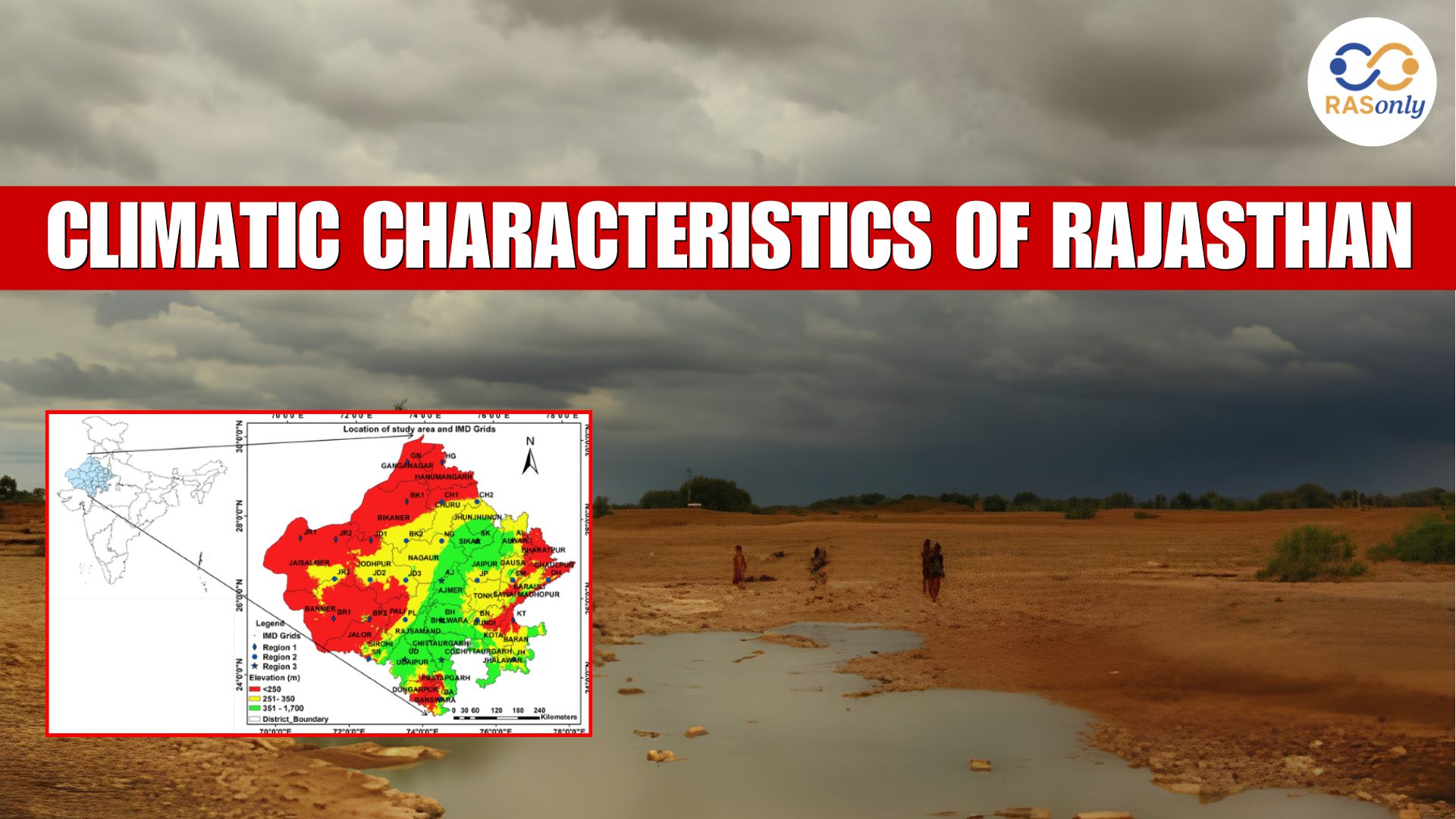
Rajasthan is the biggest state in India in terms of area, and it offers one of the most interesting and diverse climatic scenarios in the country. Rajasthan has extreme climatic conditions ranging from the scorching hot deserts of Thar to the relatively cooler hills of Mount Abu in just a span of the country. These climatic features become crucial for everyone appearing for the RAS exam and learning Rajasthan Geography notes, since these features appear in almost all the RAS exams in one or another capacity every year.
In this article, we'll break down the climatic characteristics of Rajasthan in a way that's easy to remember, exam-ready, and covers everything from climate classification to rainfall patterns and the factors that shape this unique climate.
What Type of Climate Does Rajasthan Have?
Rajasthan has a predominantly dry continental type of climate with high diurnal (day-night) temperature variation and low and unpredictable rainfall. This is mainly due to its location being in the rain-shadow belt and remote from any large water body except for that along the coastal influence of the Rann of Kutch border.
Broadly, Rajasthan's climate can be divided based on the Aravalli range, which acts as a natural divider:
- Western Rajasthan - Hot desert climate, extremely dry, very low rainfall
- Eastern Rajasthan - Semi-arid to sub-humid climate, comparatively better rainfall and vegetation
This east-west divide is the foundation of almost every question asked about Rajasthan's climatic regions in RAS mains and prelims.
Climatic Regions of Rajasthan
Geographers and climatologists typically classify Rajasthan into the following climatic regions. This classification is one of the most frequently asked parts of Rajasthan climate notes for RAS aspirants.
1. Arid Climate Region (Western Rajasthan)
This covers districts like Jaisalmer, Barmer, Bikaner, and Churu. It is marked by:
- Annual rainfall below 20 cm
- Extremely hot summers, often crossing 48°C
- Cold winters with temperatures dropping close to freezing at night
- High wind velocity and frequent dust storms
2. Semi-Arid Climate Region (Transitional Zone)
It is a region located between the Thar desert and the more fertile eastern plains, which include parts of Ajmer, Jodhpur, and Nagaur. The rainfall here is 40-60cm per year with thorny scrub-type vegetation.
3. Sub-Humid Climate Region (Eastern and South-Eastern Rajasthan)
Covering Kota, Bundi, Jhalawar, and parts of Udaipur, this region receives comparatively higher rainfall (60-100 cm) due to the influence of the retreating monsoon and better vegetation cover.
4. Humid Climate Region (Mount Abu and Surrounding Hills)
Mount Abu, being the only hill station in Rajasthan, enjoys a relatively cooler and more humid climate compared to the rest of the state, with rainfall exceeding 150 cm in some pockets - the highest in Rajasthan.
Climate Classification of Rajasthan (Koppen's Classification)
For RAS mains, examiners often expect students to relate Rajasthan's climate to standard scientific classification systems. According to the Koppen Climate Classification, most of Rajasthan falls under:
- BWhw - Hot desert climate (Western Rajasthan)
- BShw - Hot semi-arid steppe climate (Transitional belt)
- Cwg - Humid subtropical climate with dry winters (parts of southeastern Rajasthan and Mount Abu)
Memorizing these codes with their corresponding regions is a smart way to score extra marks in mains-level answers.
Factors Affecting the Climate of Rajasthan
Understanding why Rajasthan has such an extreme and diverse climate is just as important as knowing what the climate is. Here are the major factors:
1. Latitude and Location Rajasthan lies between 23°3' N and 30°12' N latitude, placing a large part of it within the sub-tropical high-pressure belt, which is naturally dry.
2. Distance from the Sea Except for a small southwestern edge, most of Rajasthan is far from the sea, cutting off the moderating and moisture-bearing effect of oceanic winds.
3. The Aravalli Range Unlike most mountain ranges in India, the Aravallis run parallel to the monsoon winds rather than perpendicular to them. This means they fail to block or lift the moisture-laden winds, so most of the monsoon simply passes over Western Rajasthan without dropping rain - one of the most unique and frequently tested facts in Rajasthan geography notes.
4. Presence of the Thar Desert The Thar Desert amplifies daytime heating and reduces humidity retention, contributing to the extreme summer temperatures of Western Rajasthan.
5. Wind Patterns Hot, dry winds known as "loo" dominate Rajasthan in summer, while cold winds from the northwest bring chilly winters, especially in December-January.
Seasons in Rajasthan
Rajasthan experiences three broad seasons, similar to the rest of India, but with sharper extremities:
- Summer (March to June): Temperatures can soar past 48°C in places like Churu and Ganganagar, making these among the hottest locations in the entire country.
- Monsoon (July to September): Rainfall is highly erratic and unevenly distributed - southeastern Rajasthan may receive good rain while the western desert remains almost untouched.
- Winter (October to February): Nights can be bitterly cold, especially in Churu, Sikar, and Mount Abu, sometimes recording sub-zero temperatures.
Rainfall Pattern in Rajasthan
Rajasthan's rainfall pattern is one of the most irregular in India, both spatially and temporally.
- Average annual rainfall: approximately 57 cm (well below the national average)
- Rainfall decreases from east to west and from south to north
- Mount Abu records the highest rainfall in the state
- Jaisalmer records the lowest rainfall, sometimes less than 10 cm annually
- Around 90% of the total annual rainfall occurs during the southwest monsoon (July-September)
This uneven rainfall distribution directly explains why agriculture, drinking water availability, and even population density vary so drastically between eastern and western Rajasthan - a connection RAS examiners love to test.
Why This Topic Matters for RAS and RPSC Exams
The climatic characteristics of Rajasthan connect directly to several other important topics - soil types, natural vegetation, agricultural patterns, and even administrative planning for drought-prone areas. Understanding this topic well will make it much easier to answer related questions on Rajasthan's desert development programs, irrigation projects like the Indira Gandhi Canal, and disaster management related to drought and dust storms.
Conclusion - Climatic Characteristics of Rajasthan
The climate of Rajasthan is extreme in every aspect, from the hot deserts in the western part of the state to the moderate rainfall areas in the eastern part to the small humid area around Mount Abu. These climatic regions are closely related to the soil, vegetation, and agriculture of the region and therefore are very closely related to the rest of the geography notes of Rajasthan. Knowing these features of Rajasthan is a good base for some of the questions related to Rajasthan and climate, which are asked in the prelims and mains of the RAS exam.
FAQs - Climatic Characteristics of Rajasthan
Rajasthan has a dry, continental climate, ranging from hot desert conditions in the west to semi-arid and sub-humid conditions in the east.
The four main regions are the Arid region (west), Semi-Arid region (transitional), Sub-Humid region (east/southeast), and the Humid region around Mount Abu.
Because the Aravalli Range runs parallel to the monsoon winds instead of blocking them, the moisture-laden clouds pass over Western Rajasthan without releasing significant rainfall.
Mount Abu is the wettest place, receiving over 150 cm of rainfall, while Jaisalmer is the driest, often recording under 10-20 cm annually.
Most of Rajasthan falls under BWhw (hot desert) and BShw (hot semi-arid), with small pockets of Cwg (humid subtropical with dry winters) near Mount Abu and southeastern districts.

BEST SELLER
🏆 PRELIMS
RAS Pass
Prelims focused Hindi & English
₹399
✓
Prelims Topic-Wise Tests
✓
Subject-Wise Tests
✓
Full-Length Prelims Tests
✓
Daily Current Affairs Tests
✓
Prelims PYQs Tests
✓
Detailed Solutions & Analysis
✓
All Rajasthan Ranking
✓
Unlimited Reattempts
✓
Mains Tests
✓
Hindi & English Tests
✓
All Rajasthan Ranking
Trusted by 5,000+ Students
Post Category
- RAS Salary
- Result
- RAS Admit Card
- RAS Job
- RAS Cutoff
- Preparation Tips
- RAS Answer Key
- RAS Exam Analysis
- RAS Syllabus
- RAS Previous Year Papers
- RPSC RAS Exam Pattern
- RAS Interview
- RAS Exam Date
- RAS Vacancy
- RAS Test Series
- RAS Best Books
- RAS Preparation Resources
- RAS Coaching Centre
- History
- Polity
- Geography
- Economics
- Science
- Art and Culture
- RPSC RAS Application Form
- RPSC RAS Notification
- RAS Eligibility Criteria
- UPSC Exam
- RPSC RAS Mains
Visit Our RASonly Offline Center
Our Expert Faculty

Bhunesh Sir
Current Affairs · 13+ Yrs

Aamir Khan Sir
RAS-2017 · IIM Ahm.

Akash Sir
Polity · 8+ Yrs
Free Resources
Official Mobile App

RASOnly App
by OTSAdda · Free
Full Video Lectures
Mock Tests & PYQs
Daily Current Affairs
AI Mock Interview
Free Download · No subscription needed to install
RAS 2024 Toppers — RASonly
Rank 2
Virendra Charan
Rank 9
Bhoopinder Singh
Rank 26
Aanchal Nagpal
Rank 33
Lokendra Singh
Rank 45
Amar Rathore
Rank 46
Manasvini Verma

Join RASonly WhatsApp Community
Get daily current affairs, exam alerts, free study material and tips from expert faculty — right on WhatsApp.
Join for Free →RASonly Interview Guidance Program

Mr. Ashok Jain
Ex-Chief Secretary Govt of Rajasthan
- IAS officer of the 1981 batch, Rajasthan cadre.
- Passionate about mentoring the next generation of RAS officers with real-world insights.
- Got retired in Dec 2017 from the post of Chief Secretary of the state of Rajasthan.

Mr. Guru Charan Rai
Ex-ASP / SP in Jaisalmer
- Guru Charan Rai, IPS (Retd), retired as Inspector General of Police (Security), Rajasthan, Jaipur in 2017.
- Served as ASP and SP in Jaisalmer, Nagaur, Sri Ganganagar, Sawai Madhopur, Dausa, Sikar, and Karauli.
- He also held key positions as DIGP and IGP in the Law and Order division.

Mr. Rakesh Verma
Ex-IAS Officer, B.Tech, MBA, and M.A. (Economics)
- IAS officer of the 1981 batch and retired in Chief Secretary Rank.
- Civil servant of high repute and vast experience.
- Has been teaching UPSC CSE subjects for the last six years.
Related Post




Daily Current Affairs for RAS Exam Preparation 2026

Financial Approval Granted for the Development of Religious Sites
October 05, 2026
IIT Madras Signs MoU for Joint Educational Programmes
October 05, 2026
Niharika Rathore Wins MIS Global India Title
October 03, 2026