Pallava Dynasty: Major Rulers, Temple Architecture and Contributions to South India
Forests of Rajasthan: Types, Distribution, and Conservation

Get in Touch with RASonly!

Forests of Rajasthan cover barely 4.9% of the state's geographical area, making it the least forested large state in India despite being the country's biggest state by size. Cutting through this arid landscape, the Aravalli range decides almost everything about where these forests survive. For RAS aspirants, understanding forest classification, district-wise spread, wildlife sanctuaries, and conservation policy in Rajasthan is essential since this topic returns year after year in Prelims and Mains.

Rajasthan is the largest state of India, spread across nearly 3,42,239 square kilometers, yet it remains one of the least forested states in the country. Most of the western half lies within the Thar Desert, while the Aravalli hill range cuts diagonally through the state and shapes almost everything about where the forests of Rajasthan actually grow. Understanding the forest cover, classification, and conservation status of Rajasthan is an important part of the RAS syllabus, since questions on forest types, wildlife sanctuaries, and forest policy appear regularly in both the Prelims and Mains geography and environment sections.
This article puts together everything a RAS aspirant needs on the topic—legal classification of forest land, the Champion and Seth forest type classification, district-wise distribution, major wildlife sanctuaries and national parks, and the state's forest conservation policy - all in one place, along with quick revision points and frequently asked questions.
Forest Cover of Rajasthan: Key Statistics
Despite its huge geographical size, Rajasthan has only a small share of its land under recorded forest. According to the Forest Survey of India, the Recorded Forest Area (RFA) of the state is about 32,863 sq km, which works out to roughly 9.6% of the state's geographical area - well below the national average. The actual forest cover, as measured through satellite imagery, is even lower, at around 16,655 sq km, or close to 4.9% of the state's area. This gap between 'recorded forest' and 'actual forest cover' is itself a favourite exam point, since it shows how much recorded forest land in Rajasthan is degraded, under encroachment, or simply too arid to support dense tree growth.
| Indicator | Value | Remark |
|---|---|---|
| Geographical Area of Rajasthan | 3,42,239 sq km | Largest state in India by area |
| Recorded Forest Area (RFA) | 32,863 sq km (~9.6%) | Legally notified forest land |
| Actual Forest Cover (Satellite Based) | 16,654.96 sq km (~4.87%) | Lowest forest cover among large states |
| Very Dense Forest (VDF) | 78.15 sq km | Negligible share of total cover |
| District with Highest Forest Cover | Udaipur (2,753.39 sq km) | Aravalli and southern hill tracts |
| Scrub Area | 4,808.04 sq km | Degraded / open forest patches |
Legal Classification of Forests in Rajasthan
Based on ownership and the degree of legal protection, the forests of Rajasthan are divided into three categories under the Indian Forest Act. This classification decides how much local communities are allowed to use forest resources like fuelwood, grazing land, and minor produce.
| Category | Area | Share of Forest Area | Key Feature |
|---|---|---|---|
| Reserved Forest | 12,176 sq km | 37.0% | Highest protection; local use is restricted |
| Protected Forest | 18,543 sq km | 56.4% | Government managed; limited grazing and fuelwood collection allowed |
| Unclassed Forest | 2,144 sq km | 6.5% | Least protected; no major restriction on cutting or grazing |
Notice that Protected Forest, not Reserved Forest, forms the largest share of Rajasthan's forest land - this is the reverse of the pattern seen in many other Indian states and is a small but useful detail to remember for objective-type questions.
Forest Types of Rajasthan: Champion and Seth Classification
The most scientific and widely used system for classifying Indian forests is the Champion and Seth Classification (1968), based on rainfall, temperature, altitude, and species composition. Out of the sixteen forest type-groups identified for India as a whole, the forests of Rajasthan fall under only two broad type-groups, both belonging to the 'Dry Tropical Forest' major group - a direct result of the state's low and erratic rainfall.
1. Tropical Dry Deciduous Forest
These forests are found mainly in the southern and south-eastern parts of the state, in districts such as Udaipur, Chittorgarh, Kota, Baran, Jhalawar, Sirohi, Banswara, and Dungarpur, where average rainfall exceeds 60 cm a year. This type-group accounts for roughly one-fifth of the state's total forest cover. Dominant species include Anogeissus pendula (Dhok), Anogeissus latifolia, Terminalia tomentosa, Terminalia arjuna, Terminalia chebula, and Albizia lebbeck. Around Mount Abu, a distinct pocket of sub-tropical vegetation is also found, resembling plant communities of the lower Himalayan foothills.
2. Tropical Thorn Forest
This is the dominant forest type of Rajasthan by area, spread across the arid and semi-arid western districts including Jodhpur, Pali, Jalore, Barmer, Nagaur, Churu, and Bikaner, as well as parts of the northern and eastern Aravalli slopes in Alwar, Bharatpur, and Dholpur. Rainfall here is generally below 70 cm annually. The vegetation is open, scrubby, and drought-resistant, with common species such as Acacia nilotica, Acacia leucophloea, Prosopis cineraria (Khejri - the state tree), Capparis aphylla, Zizyphus species, and Salvadora species.
| Forest Type | Major Districts | Average Rainfall | Key Species |
|---|---|---|---|
| Tropical Dry Deciduous | Udaipur, Chittorgarh, Kota, Baran, Jhalawar, Banswara | > 60 cm | Anogeissus pendula, Terminalia species |
| Tropical Thorn Forest | Jodhpur, Barmer, Bikaner, Nagaur, Jalore, Churu | < 70 cm | Acacia nilotica, Prosopis cineraria, Zizyphus |
District-Wise Distribution of Forests
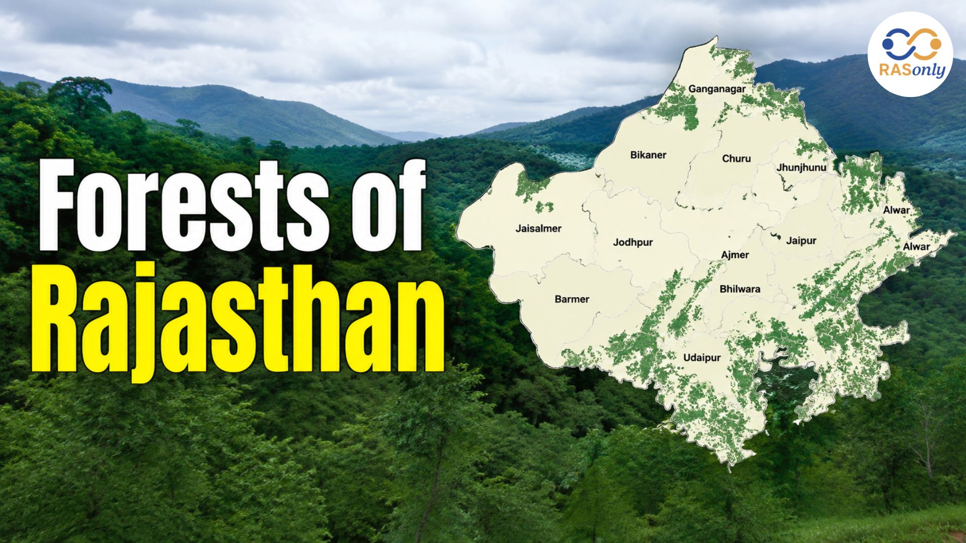
Forest cover in Rajasthan is heavily concentrated in the southern and south-eastern districts along the Aravalli range, while the western desert districts have very little natural forest. Udaipur alone accounts for the single largest forest cover in the state, largely because of its hilly Aravalli terrain and comparatively higher rainfall. In contrast, desert districts such as Jaisalmer, Bikaner, and Barmer have minimal recorded forest area, though they support other important ecosystems such as the Desert National Park's grassland and scrub habitat.
- Highest forest cover (area-wise): Udaipur
- Forest cover concentrated along: the Aravalli hill range, running from Sirohi/Mount Abu in the south-west to Alwar in the north-east
- Lowest forest presence: western desert districts such as Jaisalmer, Bikaner, Churu, and Barmer
- Region with maximum forest type diversity: South and south-eastern Rajasthan (Udaipur, Chittorgarh, Kota, Banswara belt)
Major Wildlife Sanctuaries and National Parks
Rajasthan's forests, though limited in area, support a remarkable diversity of wildlife, from tigers in the dry deciduous forests of the south-east to the Great Indian Bustard in the desert grasslands of the west. The state's protected area network is an important part of both the forest and environment sections of the RAS syllabus.
| Protected Area | District | Known For |
|---|---|---|
| Ranthambore National Park | Sawai Madhopur | Tiger reserve, dry deciduous forest |
| Sariska Tiger Reserve | Alwar | Tiger reserve in the Aravalli hills |
| Keoladeo National Park | Bharatpur | UNESCO World Heritage wetland, migratory birds |
| Desert National Park | Jaisalmer / Barmer | Great Indian Bustard habitat, desert ecosystem |
| Mount Abu Wildlife Sanctuary | Sirohi | Only hill station of Rajasthan; sub-tropical forest |
| Kumbhalgarh Wildlife Sanctuary | Rajsamand / Udaipur / Pali | Wolves, leopards, Aravalli forest |
| Tal Chhapar Sanctuary | Churu | Blackbuck habitat in grassland |
| Darrah National Park | Kota | Dry deciduous forest, tigers and leopards |
Forest Policy and Conservation Efforts in Rajasthan
Given how limited its natural forest cover already is, Rajasthan's forest department has focused heavily on afforestation, watershed-linked plantation drives, and community participation in forest protection. Key initiatives include the Aravalli Green Wall Project, which aims to restore degraded stretches of the Aravalli range through large-scale plantation; social and farm forestry programmes that encourage tree planting outside notified forest land; and Joint Forest Management (JFM) committees that give local communities a direct stake in protecting nearby forest patches.
- Aravalli Green Wall Project - large-scale afforestation along the Aravalli range to check desertification
- Joint Forest Management (JFM) - community-based forest protection and benefit-sharing model
- Social and farm forestry - promoting tree cover outside recorded forest area (a major reason for Rajasthan's rising tree cover in recent ISFR reports)
- Desertification control - shelterbelt plantations and sand dune stabilisation in western districts
Interestingly, recent India State of Forest Report assessments have flagged Rajasthan among the states showing the fastest increase in tree cover outside traditional forest areas - a trend directly linked to plantation and conservation drives rather than the growth of natural forest, which is an important nuance for Mains-level answers.
Quick Revision Points for RAS Exam
- Rajasthan has the lowest forest cover percentage among India's large states - roughly 4.9% of its geographical area.
- Recorded Forest Area (RFA) is about 9.6% of the state's area, higher than the actual satellite-measured forest cover.
- Protected Forest (56.4%) is the largest legal category of forest land in Rajasthan, ahead of Reserved Forest (37%).
- Rajasthan's forests fall under only two Champion & Seth type-groups: Tropical Dry Deciduous Forest and Tropical Thorn Forest.
- Udaipur district has the highest forest cover by area in the state.
- Prosopis cineraria (Khejri) is the state tree of Rajasthan and a dominant species of the thorn forest.
- Keoladeo National Park (Bharatpur) is a UNESCO World Heritage Site.
- Desert National Park (Jaisalmer-Barmer) is the key habitat of the critically endangered Great Indian Bustard.
Important Links
Conclusion
The forests of Rajasthan may be limited in size, but they are far from insignificant. From the Tropical Dry Deciduous belt around Udaipur and Chittorgarh to the Tropical Thorn forests stretching across Jodhpur, Barmer, and Bikaner, each type reflects the state's unique struggle against aridity and desertification. Add to this the state's ambitious afforestation drives like the Aravalli Green Wall Project, its network of tiger reserves and bird sanctuaries, and its complex legal classification of forest land, and this topic becomes one of the richest environment-related areas in the RAS syllabus. Revisiting the key statistics, forest types, and protected areas covered in this article should give you a strong, exam-ready command of the subject.
FAQs
As per the latest Forest Survey of India assessment, actual forest cover in Rajasthan is close to 4.9% of the state's geographical area, while the Recorded Forest Area is about 9.6%.
Rajasthan has two major forest type groups: Tropical Dry Deciduous Forest, found mainly in the southern and south-eastern districts, and Tropical Thorn Forest, which dominates the arid western and northern districts.
Udaipur district has the highest forest cover by area in Rajasthan, owing to its location within the Aravalli hill range and comparatively higher rainfall.
Reserved Forest has the highest degree of legal protection, with restricted access for local communities, while Protected Forest allows limited grazing and collection of minor forest produce under government supervision. In Rajasthan, Protected Forest actually covers a larger area than Reserved Forest.
The state tree of Rajasthan is Prosopis cineraria, locally known as Khejri. It is highly drought-resistant and forms the backbone of the tropical thorn forest ecosystem, besides being central to the historic, Chipko-inspiring Khejarli sacrifice movement.

BEST SELLER
🏆 PRELIMS
RAS Pass
Prelims focused Hindi & English
₹399
✓
Prelims Topic-Wise Tests
✓
Subject-Wise Tests
✓
Full-Length Prelims Tests
✓
Daily Current Affairs Tests
✓
Prelims PYQs Tests
✓
Detailed Solutions & Analysis
✓
All Rajasthan Ranking
✓
Unlimited Reattempts
✓
Mains Tests
✓
Hindi & English Tests
✓
All Rajasthan Ranking
Trusted by 5,000+ Students
Post Category
- RAS Salary
- Result
- RAS Admit Card
- RAS Job
- RAS Cutoff
- Preparation Tips
- RAS Answer Key
- RAS Exam Analysis
- RAS Syllabus
- RAS Previous Year Papers
- RPSC RAS Exam Pattern
- RAS Interview
- RAS Exam Date
- RAS Vacancy
- RAS Test Series
- RAS Best Books
- RAS Preparation Resources
- RAS Coaching Centre
- History
- Polity
- Geography
- Economics
- Science
- Art and Culture
- RPSC RAS Application Form
- RPSC RAS Notification
- RAS Eligibility Criteria
- UPSC Exam
- RPSC RAS Mains
Visit Our RASonly Offline Center
Our Expert Faculty

Bhunesh Sir
Current Affairs · 13+ Yrs

Aamir Khan Sir
RAS-2017 · IIM Ahm.

Akash Sir
Polity · 8+ Yrs
Free Resources
Official Mobile App

RASOnly App
by OTSAdda · Free
Full Video Lectures
Mock Tests & PYQs
Daily Current Affairs
AI Mock Interview
Free Download · No subscription needed to install
RAS 2024 Toppers — RASonly
Rank 2
Virendra Charan
Rank 9
Bhoopinder Singh
Rank 26
Aanchal Nagpal
Rank 33
Lokendra Singh
Rank 45
Amar Rathore
Rank 46
Manasvini Verma

Join RASonly WhatsApp Community
Get daily current affairs, exam alerts, free study material and tips from expert faculty — right on WhatsApp.
Join for Free →RASonly Interview Guidance Program

Mr. Ashok Jain
Ex-Chief Secretary Govt of Rajasthan
- IAS officer of the 1981 batch, Rajasthan cadre.
- Passionate about mentoring the next generation of RAS officers with real-world insights.
- Got retired in Dec 2017 from the post of Chief Secretary of the state of Rajasthan.

Mr. Guru Charan Rai
Ex-ASP / SP in Jaisalmer
- Guru Charan Rai, IPS (Retd), retired as Inspector General of Police (Security), Rajasthan, Jaipur in 2017.
- Served as ASP and SP in Jaisalmer, Nagaur, Sri Ganganagar, Sawai Madhopur, Dausa, Sikar, and Karauli.
- He also held key positions as DIGP and IGP in the Law and Order division.

Mr. Rakesh Verma
Ex-IAS Officer, B.Tech, MBA, and M.A. (Economics)
- IAS officer of the 1981 batch and retired in Chief Secretary Rank.
- Civil servant of high repute and vast experience.
- Has been teaching UPSC CSE subjects for the last six years.
Related Post


Daily Current Affairs for RAS Exam Preparation 2026

Abhaneri Festival 2026
October 12, 2026
CAZRI Moth Bean Varieties Withstand 35-Day Dry Spell 2026
October 12, 2026
Public Pledge Against Drug Abuse
October 10, 2026