Gupta Empire, Founder, Time Period, Rulers, Map, Capital City
Luni-Jawai Basin of Rajasthan: Complete Geography Notes

Get in Touch with RASonly!

The Luni-Jawai Basin is the largest west-flowing river basin in Rajasthan. It plays an important role in the state's geography, supporting agriculture, groundwater recharge, irrigation, and rural livelihoods. Its unique inland drainage system, saline river course, and Jawai Dam make it an important topic for Rajasthan GK and competitive exams.

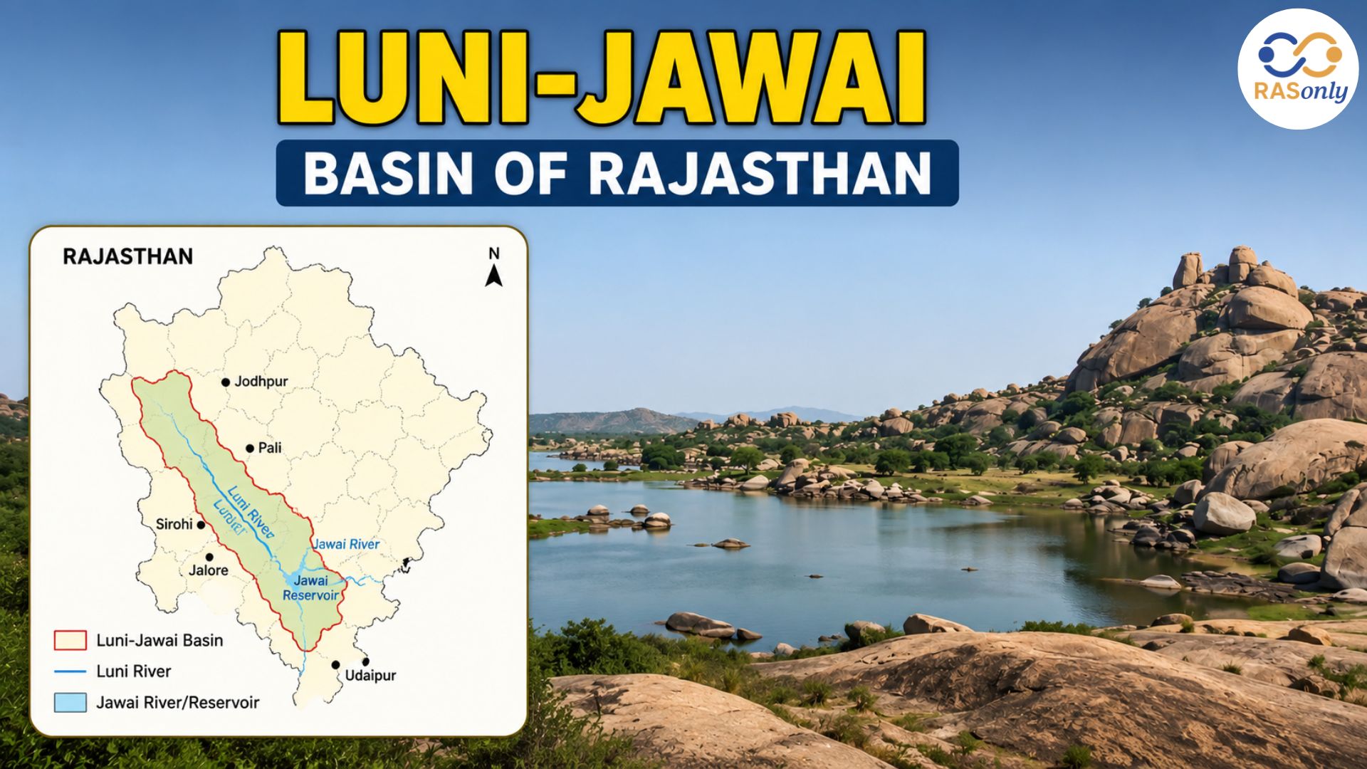
Luni-Jawai Basin is one of the important river basins of western Rajasthan and it is the largest west-flowing river basin of the state. Formed by the Luni River and its largest tributary, the Jawai River, this basin plays a vital role in shaping the physical geography, ecology, and economy of the Thar Desert region. The river systems of east-flowing in the desert of Rajasthan have a different drainage pattern from that of the Luni-Jawai Basin, which is an inland (endorheic) drainage system. Instead, the river gradually loses its flow in the marshy expanses of the Rann of Kutch in Gujarat. The river is saline through its lower course, but is one of the most important geographical features of the State as it supports agriculture, recharges groundwater, irrigation projects, and rural settlements in some of the driest districts of the State.
Origin of the Luni River
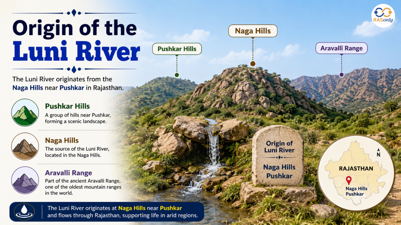
The Luni River originates from the western slopes of the Naga Hills (Pushkar), which form a part of the ancient Aravalli Range in Ajmer district. At its source, the river carries fresh water and is initially known as the Sagarmati River. As it continues its journey, it meets the Sarsuti (Saraswati) River near Govindgarh, after which it acquires the name Luni. The basin belongs to the inland drainage (endorheic) system, making it unique because its water never reaches the ocean. The river starts at high altitudes in the Aravalli Range and flows into the dry lands of western Rajasthan, the cradle of many desert villages.
| Feature | Detail |
|---|---|
| Origin point | Naga Hills (Pushkar), Aravalli Range |
| District | Ajmer |
| Elevation | ~550–772 m |
| Initial name | Sagarmati |
| Renamed to Luni | After meeting tributary Sarsuti (Saraswati) near Govindgarh |
| Basin type | Inland drainage / Endorheic basin |
Course and Length of Luni River
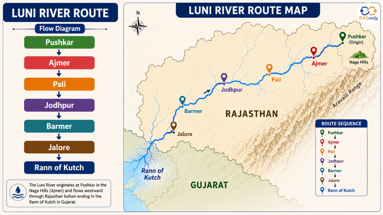
After emerging from the Aravalli hills, the Luni River follows a long and winding course across western Rajasthan. The river bends many times in its path due to the rough topography of the Aravalli hills and the flat land of Marwar. Initially, it flows towards the northwest before turning southwest as it enters the plains. It is fed by some seasonal tributaries en route, which together constitute the largest river system of western Rajasthan. After crossing Gujarat, it finally fades away into the saline stretches of the marsh in the Rann of Kutch, where it dissipates without forming a delta or flowing into the Arabian Sea.
- Flows north-west first, toward Nagaur
- Turns south-west through the Aravalli hills in Pali
- Enters the plains of the Marwar region near Jodhpur
- Passes through Barmer and Jalore
- Crosses into Gujarat and dissipates in the Rann of Kutch
- Total length: ~495 km
Tributaries of Luni
The western slopes of the Aravalli Range are drained by a well-developed network of seasonal waterways that feed into the Luni River. These tributaries play an important role during the monsoon season and support groundwater recharge in the surrounding semi-arid areas. The river receives water from most of its tributaries from the left bank, with only one important tributary joining the river from the right bank, from the Aravalli hills. The Jawai River is the most important and largest of all the rivers, as being the biggest river basin, and the Jawai dam is located here.
_1783680765.png)
| Bank | Tributaries |
|---|---|
| Left bank (from Aravalli) | Jawai, Sukri, Mithri, Bandi (Hemawas), Khari, Guhiya, Sagi |
| Right bank | Jojari (only right-bank tributary; does not originate from Aravalli) |
Districts Covered by the Basin
Luni-Jawai Basin is a large basin that covers a large area of western Rajasthan and lower part of Gujarat. The basin drains several districts that fall within the state's semi-arid and arid climatic zones. These districts are reliant on the basin for seasonal farming, recharge of water table, livestock and domestic water supplies. Together, they form the geographical region commonly known as Marwar and Godwar, where the Luni River has historically supported human settlements despite harsh desert conditions.
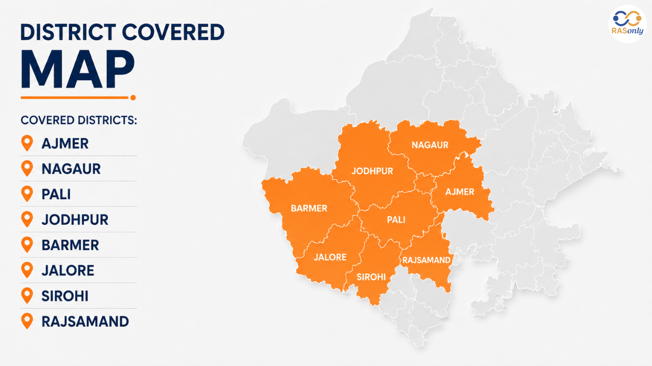
- Ajmer
- Nagaur
- Pali
- Jodhpur
- Barmer
- Jalore
- Sirohi and Rajsamand (upper catchment, partial)
- Banaskantha and Patan, Gujarat (lower reaches)
Salinity of the Luni River
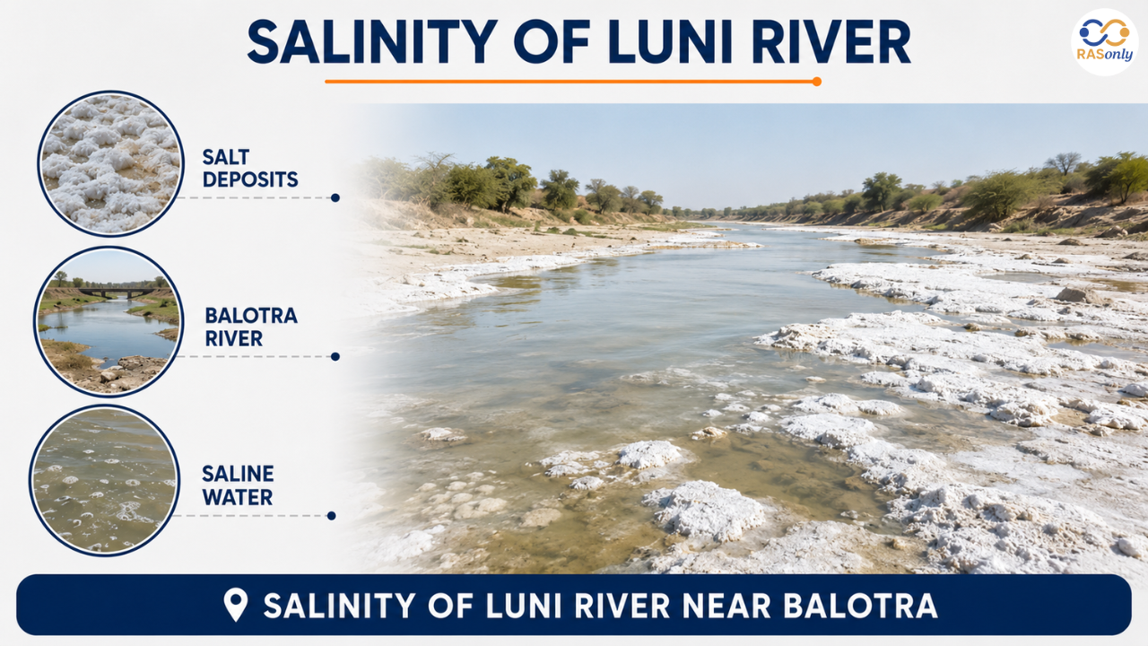
One of the most distinctive characteristics of the Luni River is its gradual transformation from a freshwater river into a saline river. The source of the river in the Aravalli hills is fresh water, which is suitable for drinking and irrigation. However, after entering the salt-rich soils of the Barmer region, particularly around Balotra, the river becomes increasingly saline as it dissolves naturally occurring salts. This unique feature is also reflected in the river's name, which is derived from the Sanskrit word Lavanavari, meaning "salt water." Even though the water becomes unsuitable for drinking in many stretches, it still plays an important role in seasonal irrigation and groundwater recharge.
| Point | Detail |
|---|---|
| Meaning of "Luni" | From Sanskrit Lavanavari / Lavanavati = Saline River |
| Water near the origin | Fresh |
| Becomes saline | After reaching Balotra, Barmer district |
| Cause | High salt content in the surrounding soil |
| Use despite salinity | Seasonal irrigation, groundwater recharge |
Jawai Dam
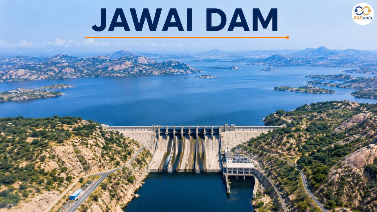
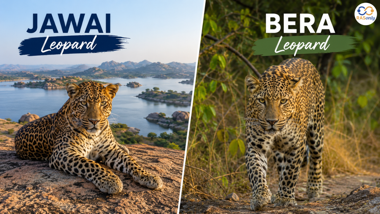
The Jawai dam, built on the Jawai river near Sumerpur, in the district of Pali, is one of the most significant multipurpose dams of Rajasthan. It supplies irrigation water to nearby agricultural lands and provides drinking water to several towns and villages. Beyond its economic importance, the area surrounding the dam has gained international recognition for the famous Bera Leopard Reserve, where leopards live peacefully alongside the Rabari pastoral community among spectacular granite hills. This rare coexistence of wildlife and humans has made Jawai one of India's emerging eco-tourism destinations.
| Feature | Detail |
|---|---|
| Other names | Jawai Bandh / Jawai Sagar Dam |
| Location | Near Sumerpur, Pali district |
| Built on | Jawai River |
| Purpose | Irrigation and drinking water supply |
| Nearby towns | Sumerpur and Sheoganj |
| Famous for | Leopard habitat in the Bera region — leopards living alongside Rabari shepherd communities among granite hills |
Drainage Pattern and Confluence Points
In the Luni-Jawai Basin, the rivers typically have a dendritic drainage pattern that naturally forms on relatively uniform rock formations. A branching system collects monsoon runoff from many streams and finally joins the major river. Several small streams converge to form the Luni River, thereby allowing groundwater recharge in the western part of Rajasthan. Since the basin belongs to an inland drainage system, the river eventually disappears in the Rann of Kutch instead of forming a delta at the sea.
| Feature | Detail |
|---|---|
| Drainage pattern | Dendritic, typical of a desert drainage system |
| Khari + Mithri confluence | Meet near Bombadra and form the Bandi River |
| Guhiya River | Joins the Bandi River near Fekaria village, Pali |
| Tributaries | All tributaries eventually merge into the main Luni River channel |
| Basin termination | Ends in an inland basin without forming a delta |
Economic and Geographic Significance
Although the Luni River becomes saline in its lower reaches, the basin remains one of the most economically valuable geographical regions of western Rajasthan. It helps farmers in water-limited regions, recharges subsurface aquifers in the monsoon season, and supplies water for animals and rural populations. The Jawai Dam has further increased the basin's importance by ensuring irrigation and drinking water supplies. Geographically, the basin is also a good example of an inland drainage system and it further helps to differentiate the west-flowing river systems of Rajasthan from the east-flowing river systems like Banas and Chambal.
- Supports agriculture in the Pali-Jalore belt
- A major source of groundwater recharge in a semi-arid climate
- Comparable saline system: Sambhar Lake
- Distinguishes west-flowing rivers of Rajasthan from east-flowing rivers (Banas, Chambal)
- Sustains rural livelihoods across the Marwar and Godwar regions
Quick Revision Table
The table below summarises all the key facts of the Luni-Jawai Basin for fast revision before an exam.
| Feature | Details |
|---|---|
| Origin | Naga Hills, Pushkar Valley, Aravalli Range (Ajmer) |
| Initial name | Sagarmati → Luni |
| Length | ~495 km |
| Termination | Rann of Kutch (Endorheic Drainage) |
| Major tributary | Jawai River |
| Other tributaries | Sukri, Bandi, Guhiya, Sagi, Mithri, Jojari |
| Districts covered | Ajmer, Nagaur, Pali, Jodhpur, Barmer, Jalore |
| Key dam | Jawai Dam (near Sumerpur, Pali) |
| Special feature | Salinity after Balotra; Leopard habitat at Bera |
Important Links
| Inland Drainage System Rivers | Lakes, and Dams of Rajasthan |
| Water Resources of Rajasthan | Aravalli Range |
| Drainage Pattern Strategy for RAS Geography | Dams of Rajasthan and Their Types |
Conclusion
The Luni-Jawai Basin is one of the finest examples of how rivers continue to sustain life even in extremely arid environments. It shows how closely the geology, climate, river systems and human settlements are related in Rajasthan. The Luni is a seasonal and saline river but sustains agriculture, groundwater recharge, livestock and rural livelihoods in a wide area of the west of Rajasthan. The presence of Jawai dam further adds to the economic importance of the basin for irrigation and drinking purposes and the presence of the globally recognised leopard habitat around Bera adds to the ecological importance. The Luni-Jawai Basin is also one of the most vital areas of study from the Rajasthan Geographical point of view as well as its salty characteristics and unique internal drainage pattern and has been a regular question item in Competitive Examinations like RAS, REET, Patwari, Rajasthan Police and other Examinations related to Rajasthan GK.
FAQs
The Luni River originates from the Naga Hills of the Aravalli Range in the Pushkar valley of Ajmer district.
The name comes from the Sanskrit word Lavanavari, and the river becomes saline after reaching Balotra because of the high salt content present in the surrounding soil.
The Luni River ends in the Rann of Kutch in Gujarat, making it an endorheic (inland drainage) river system that never reaches the sea.
The Jawai River is the largest tributary of the Luni River and originates near Goria village in Pali district, contributing significantly to the basin's drainage system.
The Jawai Dam is famous for irrigation and drinking water supply, and for the internationally known Bera leopard habitat, where leopards coexist peacefully with the Rabari community.
BEST SELLER
🏆 PRELIMS
RAS Pass
Prelims focused Hindi & English
₹399
✓
Prelims Topic-Wise Tests
✓
Subject-Wise Tests
✓
Full-Length Prelims Tests
✓
Daily Current Affairs Tests
✓
Prelims PYQs Tests
✓
Detailed Solutions & Analysis
✓
All Rajasthan Ranking
✓
Unlimited Reattempts
✓
Mains Tests
✓
Hindi & English Tests
✓
All Rajasthan Ranking
Trusted by 5,000+ Students
Post Category
- RAS Salary
- Result
- RAS Admit Card
- RAS Job
- RAS Cutoff
- Preparation Tips
- RAS Answer Key
- RAS Exam Analysis
- RAS Syllabus
- RAS Previous Year Papers
- RPSC RAS Exam Pattern
- RAS Interview
- RAS Exam Date
- RAS Vacancy
- RAS Test Series
- RAS Best Books
- RAS Preparation Resources
- RAS Coaching Centre
- History
- Polity
- Geography
- Economics
- Science
- Art and Culture
- RPSC RAS Application Form
- RPSC RAS Notification
- RAS Eligibility Criteria
- UPSC Exam
- RPSC RAS Mains
Visit Our RASonly Offline Center
Our Expert Faculty

Bhunesh Sir
Current Affairs · 13+ Yrs

Aamir Khan Sir
RAS-2017 · IIM Ahm.

Akash Sir
Polity · 8+ Yrs
Free Resources
Official Mobile App

RASOnly App
by OTSAdda · Free
Full Video Lectures
Mock Tests & PYQs
Daily Current Affairs
AI Mock Interview
Free Download · No subscription needed to install
RAS 2024 Toppers — RASonly
Rank 2
Virendra Charan
Rank 9
Bhoopinder Singh
Rank 26
Aanchal Nagpal
Rank 33
Lokendra Singh
Rank 45
Amar Rathore
Rank 46
Manasvini Verma

Join RASonly WhatsApp Community
Get daily current affairs, exam alerts, free study material and tips from expert faculty — right on WhatsApp.
Join for Free →RASonly Interview Guidance Program

Mr. Ashok Jain
Ex-Chief Secretary Govt of Rajasthan
- IAS officer of the 1981 batch, Rajasthan cadre.
- Passionate about mentoring the next generation of RAS officers with real-world insights.
- Got retired in Dec 2017 from the post of Chief Secretary of the state of Rajasthan.

Mr. Guru Charan Rai
Ex-ASP / SP in Jaisalmer
- Guru Charan Rai, IPS (Retd), retired as Inspector General of Police (Security), Rajasthan, Jaipur in 2017.
- Served as ASP and SP in Jaisalmer, Nagaur, Sri Ganganagar, Sawai Madhopur, Dausa, Sikar, and Karauli.
- He also held key positions as DIGP and IGP in the Law and Order division.

Mr. Rakesh Verma
Ex-IAS Officer, B.Tech, MBA, and M.A. (Economics)
- IAS officer of the 1981 batch and retired in Chief Secretary Rank.
- Civil servant of high repute and vast experience.
- Has been teaching UPSC CSE subjects for the last six years.
Related Post

Daily Current Affairs for RAS Exam Preparation 2026

CM Bhajan Lal Sharma Launches Rajasthan Portals
October 08, 2026
Rajasthani Film ‘Omlo’ Selected for Cannes Film Market
October 08, 2026
Rajasthan Initiative to Build India’s First UNESCO Global Geopark
October 07, 2026