Is NCERT Enough for RAS Preparation? Complete Book Strategy for Prelims & Mains
International and Interstate Boundaries of Rajasthan

Get in Touch with RASonly!

Rajasthan shares a 1,070 km international border with Pakistan and a 4,850 km interstate boundary with five Indian states. This complete guide covers district-wise boundaries, important facts, record holders, and strategic significance, making it an essential resource for RAS and Rajasthan GK preparation.
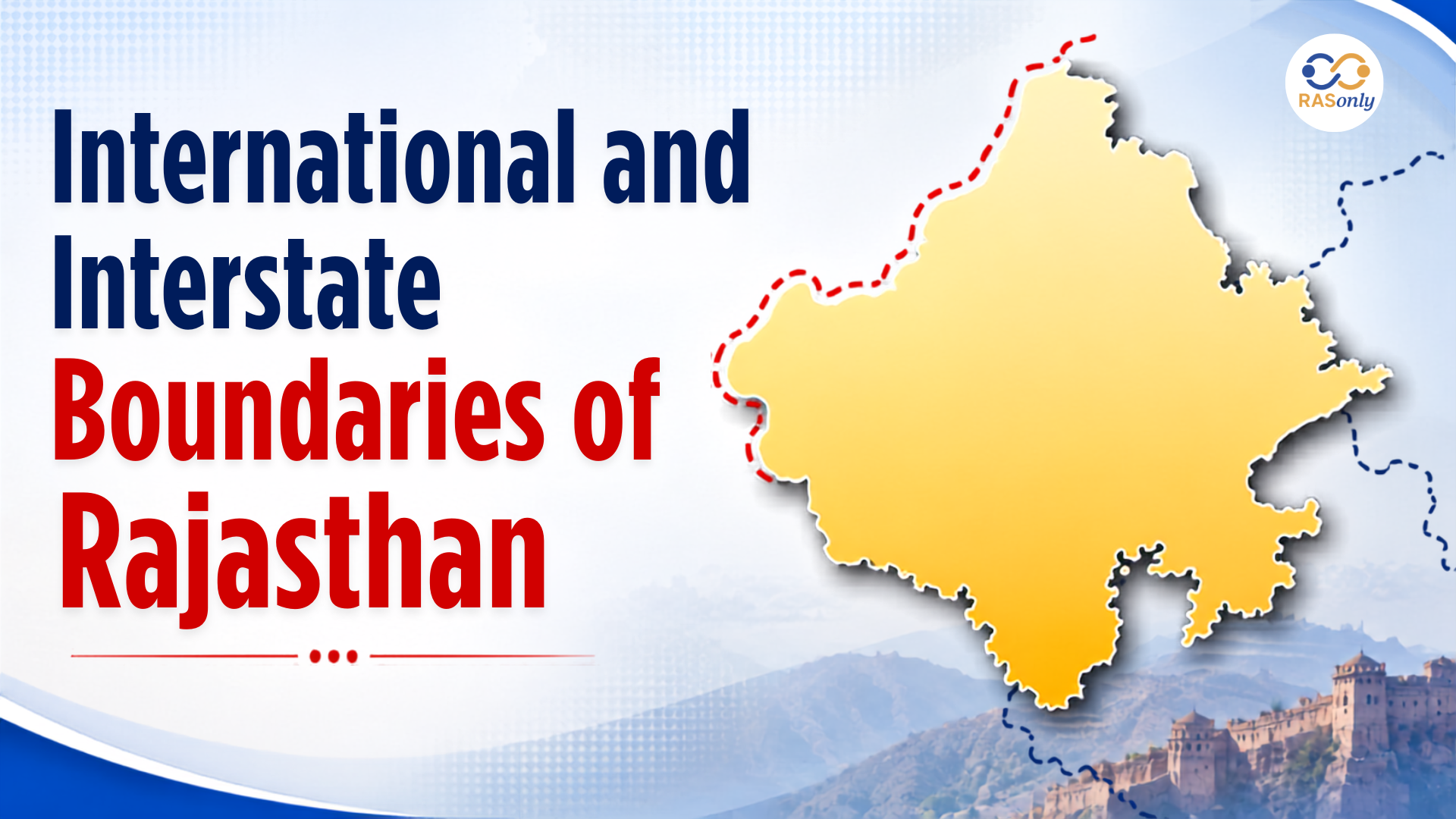
Rajasthan, India's largest state by area, holds a uniquely important place on the geographical and strategic map of the country. Sharing a 1,070 km international boundary with Pakistan along the Radcliffe Line and interstate boundaries with five states - Punjab, Haryana, Uttar Pradesh, Madhya Pradesh, and Gujarat - its total boundary stretches 5,920 km. For RAS aspirants, understanding these boundaries goes beyond memorizing numbers. District-wise details, record holders, and special boundary categories are exam favorites that appear repeatedly in both Prelims and Mains.
Overview: Total Boundary of Rajasthan
Rajasthan's total land boundary stretches over 5,920 km, making it one of the longest boundary states in India. This total is divided into two major categories:
| Type of Boundary | Length |
|---|---|
| International Boundary (with Pakistan) | 1,070 km |
| Interstate Boundary (with 5 Indian States) | 4,850 km |
| Total Boundary | 5,920 km |
This is not just a number to memorize - 5,920 km means Rajasthan touches more boundaries than most Indian states. To the west lies Pakistan, and on every other side - north, northeast, east, southeast, southwest - a different Indian state begins. Each of these borders has its own geography, its own strategic weight, and its own set of exam-relevant facts.
Part 1: International Boundary of Rajasthan
What is the Radcliffe Line?
The international boundary between India and Pakistan is known as the Radcliffe Line, named after Sir Cyril Radcliffe, who was appointed to head the Boundary Commission during the partition of British India in 1947. The Radcliffe Line was drawn hurriedly and officially announced on 17 August 1947, just two days after Indian independence.
Here is something students often overlook - the Radcliffe Line does not belong to Rajasthan alone. Its total length is 3,310 km, passing through three Indian states (Rajasthan, Gujarat, and Punjab) and two Union Territories (Jammu & Kashmir and Ladakh). Rajasthan's share is 1,070 km - the largest share among all states.
Rajasthan's Share of the International Boundary
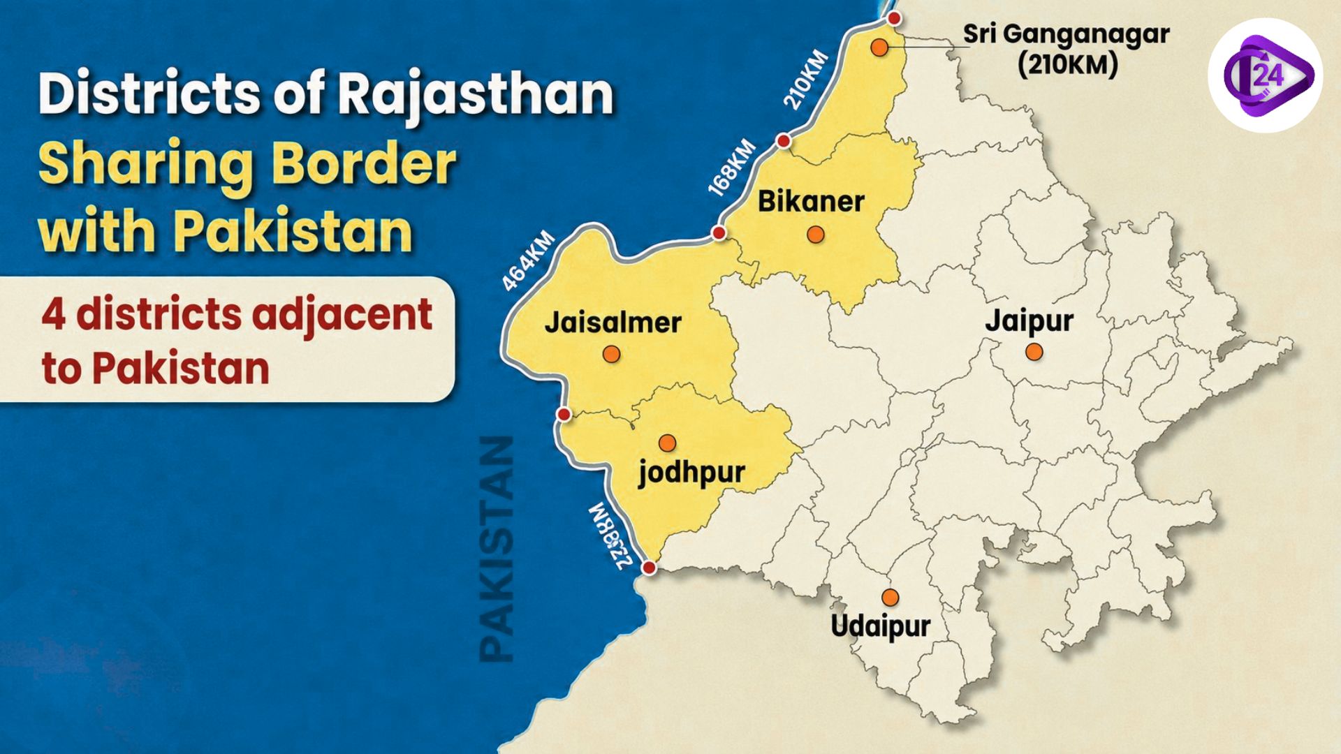
Rajasthan's 1,070 km share of the Radcliffe Line runs entirely through the Thar Desert - one of the harshest terrains in the world. It starts at Hindumalkot village in Sri Ganganagar in the north and ends at Shahgarh (also called Bakhasar) village in Barmer in the south. If you ever need to remember the starting and ending points - think north to south, Ganganagar to Barmer.
Pakistani Provinces on the Border
Two provinces of Pakistan share the boundary with Rajasthan:
| Pakistani Province | Districts Facing Rajasthan |
|---|---|
| Punjab (Pakistan) | Bahawalnagar, Bahawalpur, Rahimyar Khan |
| Sindh (Pakistan) | Ghotki, Sukkur, Khairpur, Sanghar, Umarkot, Tharparkar |
Border Districts of Rajasthan with Pakistan
Four districts of Rajasthan share the international boundary with Pakistan, arranged from North to South:
| District | Border Length | Key Point |
|---|---|---|
| Sri Ganganagar | ~210 km | Northernmost; starts at Hindumalkot; closest HQ to Pakistan border |
| Bikaner | ~168 km | Farthest HQ from Pakistan border; shortest international border |
| Jaisalmer | ~464 km | Longest international border among all districts |
| Barmer | ~228 km | Southernmost; ends at Shahgarh/Bakhasar village |
Mnemonic for RAS: "G-B-J-B" → Ganganagar → Bikaner → Jaisalmer → Barmer (North to South)
One more thing worth noting - among these four districts, students most commonly confuse border lengths. Remember: Jaisalmer is the longest (464 km), and Bikaner is the shortest (168 km).
Key Facts About the International Boundary
- The closest district headquarters to the Pakistan border is Sri Ganganagar.
- The farthest district headquarters from the Pakistan border is Bikaner.
- Jaisalmer has the longest international border (464 km) among all Rajasthan districts.
- Bikaner has the shortest international border (168 km) among the four border districts.
- The entire international boundary runs through the Thar Desert (Great Indian Desert).
- Both Sri Ganganagar and Barmer share both international and interstate boundaries.
- The Phalodi district (new district formed in 2023) also shares a small segment of the international border according to the updated administrative setup.
Part 2: Interstate Boundary of Rajasthan
Rajasthan shares its interstate boundary with five Indian states, covering a total distance of 4,850 km. These states are located in different directions:
| State | Direction from Rajasthan |
|---|---|
| Punjab | North |
| Haryana | North-East |
| Uttar Pradesh | East |
| Madhya Pradesh | South-East |
| Gujarat | South-West |
1. Punjab - 89 km (Shortest Interstate Border)
Of all five neighboring states, Punjab shares the shortest boundary with Rajasthan - just 89 km. It is easy to underestimate this border because it is small, but exam questions specifically target it as the "shortest interstate border." Two Rajasthan districts — Sri Ganganagar and Hanumangarh — cover this entire stretch.
| Rajasthan Districts | Punjab Districts |
|---|---|
| Sri Ganganagar (Longest border with Punjab) | Fazilka |
| Hanumangarh (Shortest border with Punjab) | Muktsar (Muksar) |
Key Points:
- Punjab shares the shortest interstate boundary with Rajasthan.
- Sri Ganganagar has the maximum border length with Punjab.
- Hanumangarh has the minimum border length with Punjab.
- The district headquarters near this border are Sri Ganganagar (closer) and Hanumangarh (farther).
2. Haryana - 1,262 km
Rajasthan shares a boundary of 1,262 km with Haryana in the north-eastern direction. This boundary is shared by seven districts of Rajasthan.
| Rajasthan Districts | Haryana Districts |
|---|---|
| Hanumangarh (Longest border with Haryana) | Sirsa |
| Churu | Fatehabad |
| Jhunjhunu | Hisar |
| Sikar | Bhiwani |
| Kotputli-Behror | Mahendragarh |
| Jaipur (Rural/Urban) | Rewari |
| Alwar | Mewat (Nuh) |
Key Points:
- Hanumangarh has the maximum border with Haryana.
- Jaipur has the minimum border with Haryana.
- The largest district by area on the Haryana border is Churu; the smallest is Jhunjhunu.
- Mewat (Nuh) is a newly constituted district of Haryana that touches Alwar district.
3. Uttar Pradesh - 877 km
Rajasthan shares a boundary of 877 km with Uttar Pradesh in the eastern direction. This boundary is shared by two districts of Rajasthan.
| Rajasthan Districts | UP Districts |
|---|---|
| Bharatpur (Longest border with UP) | Mathura |
| Dholpur (Shortest border with UP) | Agra |
Key Points:
- Bharatpur has the maximum border with UP.
- Dholpur has the minimum border with UP.
- The district headquarters near the UP border is Bharatpur (closer) and Dholpur (farther from HQ perspective).
- Dholpur district touches both Uttar Pradesh and Madhya Pradesh, making it a dual-border district.
4. Madhya Pradesh - 1,600 km (Longest Interstate Border)
If Punjab is one extreme, Madhya Pradesh is the other. Rajasthan shares its longest interstate boundary with MP - 1,600 km - running along the southeastern edge. Ten districts of Rajasthan touch MP, which is the highest number among all neighboring states. This section alone can give you 2 to 3 guaranteed marks in RAS Prelims if studied carefully.
| Rajasthan Districts | MP Districts |
|---|---|
| Dholpur | Sheopur |
| Karauli | Morena |
| Sawai Madhopur | Guna |
| Kota | Rajgarh |
| Baran | Agar-Malwa |
| Jhalawar (Longest border with MP) | Mandsaur |
| Chittorgarh | Neemuch |
| Bhilwara (Shortest border with MP) | Ratlam |
| Pratapgarh | Jhabua |
| Banswara | — |
Key Points:
- Madhya Pradesh shares the longest interstate boundary with Rajasthan (1,600 km).
- Jhalawar has the maximum border length with Madhya Pradesh.
- Bhilwara has the minimum border length with Madhya Pradesh.
- Chittorgarh uniquely shares the border with Madhya Pradesh twice (its territory is divided by Bhilwara district, creating two separate contact points with MP).
- 10 MP districts border Rajasthan: Jhabua, Ratlam, Mandsaur, Neemuch, Agar-Malwa, Rajgarh, Guna, Shivpuri, Sheopur, and Morena.
5. Gujarat - 1,022 km
Moving to the southwest, Rajasthan shares 1,022 km with Gujarat - covered by 6 districts. What makes this border particularly interesting for exam purposes is Barmer. It shares the longest international border with Pakistan AND the shortest interstate border with Gujarat (just 14 km).
| Rajasthan Districts | Gujarat Districts |
|---|---|
| Sirohi | Banaskantha |
| Barmer (Shortest border with Gujarat) | Patan |
| Jalore | Sabarkantha |
| Dungarpur | Mahisagar |
| Banswara | Dahod |
| Udaipur (Longest border with Gujarat) | — |
Key Points:
- Udaipur has the maximum (longest) border with Gujarat.
- Barmer has the minimum (shortest) border with Gujarat - just 14 km.
- Near the Gujarat border, the district headquarters closer to the border is Dungarpur, and the farther one is Barmer.
- The largest district by area on the Gujarat border is Barmer; the smallest is Dungarpur.
- Banswara district touches both Gujarat and Madhya Pradesh (a dual-border district).
Part 3: State-wise Interstate Boundary Summary Table
| State | Border Length | No. of Rajasthan Districts | Max Border District | Min Border District |
|---|---|---|---|---|
| Punjab | 89 km | 2 | Sri Ganganagar | Hanumangarh |
| Haryana | 1,262 km | 7 | Hanumangarh | Jaipur |
| Uttar Pradesh | 877 km | 2 | Bharatpur | Dholpur |
| Madhya Pradesh | 1,600 km | 10 | Jhalawar | Bhilwara |
| Gujarat | 1,022 km | 6 | Udaipur | Barmer |
| Total | 4,850 km | 25 | — | — |
Part 4: Special Categories of Districts
Districts Sharing Border with Two States
These four districts of Rajasthan are unique, as they border two different Indian states simultaneously:
| District | States Touching |
|---|---|
| Hanumangarh | Punjab + Haryana |
| Bharatpur | Haryana + Uttar Pradesh |
| Dholpur | Uttar Pradesh + Madhya Pradesh |
| Banswara | Madhya Pradesh + Gujarat |
Districts Sharing Both International and Interstate Boundaries
| District | International Boundary | Interstate Boundary |
|---|---|---|
| Sri Ganganagar | Pakistan | Punjab, Haryana |
| Barmer | Pakistan | Gujarat |
Inland/Landlocked Districts of Rajasthan (No Border at All)
These districts do not touch any state or international boundary:
- Jaipur, Dausa, Tonk, Bundi, Ajmer, Beawar, Didwana-Kuchaman, Nagaur, Jodhpur, Balotra, Pali, Rajsamand, Salumber
Total Inland Districts: 13
Districts Touching the Maximum Number of Other Districts
- Pali district shares its boundary with the maximum number of districts in Rajasthan - 8 districts.
Part 5: Key Facts & Figures at a Glance
| Question | Answer |
|---|---|
| Total boundary of Rajasthan | 5,920 km |
| International boundary | 1,070 km (with Pakistan) |
| Interstate boundary | 4,850 km (with 5 states) |
| Name of international boundary | Radcliffe Line |
| Drawn by | Sir Cyril Radcliffe (1947) |
| Starts at | Hindumalkot (Sri Ganganagar) |
| Ends at | Shahgarh/Bakhasar (Barmer) |
| Pakistani provinces on the border | Punjab (Pakistan) and Sindh |
| Districts on Pakistan border | 4 (Sri Ganganagar, Bikaner, Jaisalmer, Barmer) |
| Longest international border district | Jaisalmer (464 km) |
| Shortest international border district | Bikaner (168 km) |
| Nearest HQ to Pakistan | Sri Ganganagar |
| Farthest HQ from Pakistan | Bikaner |
| Total interstate border districts | 25 |
| Total inland districts (no border) | 13 |
| Longest interstate border (state) | Madhya Pradesh (1,600 km) |
| Shortest interstate border (state) | Punjab (89 km) |
| Max border district with MP | Jhalawar |
| Max border district with Gujarat | Udaipur |
| Min border district with Gujarat | Barmer (14 km) |
| District bordering two states | Hanumangarh, Bharatpur, Dholpur, Banswara |
| Districts touching 0 borders | 13 (Inland/Landlocked) |
| Total border districts (any type) | 28 |
Part 6: Strategic & Geographical Significance
A 1,070 km desert border with a neighboring country is not just a geographical fact - it shapes everything about western Rajasthan. The Thar Desert, which covers most of this boundary, has historically acted as a natural barrier. It slowed invasions, shaped settlements, and continues to define how defense infrastructure is planned in this region today.
Defense Significance: The districts bordering Pakistan - Sri Ganganagar, Bikaner, Jaisalmer, and Barmer - house several important military installations, Border Security Force (BSF) posts, and airbases. The Indian Army and BSF maintain a vigilant presence in this entire stretch. The Suratgarh Air Force Base and Nal Air Force Base in Bikaner are critical military assets.
Cultural Impact: The border regions have historically maintained cultural and linguistic connections with Pakistani Punjab and Sindh. Languages like Marwari, Sindhi, and Punjabi are spoken across both sides of the border. Festival traditions, folk music, and culinary habits show strong cross-border similarities.
Economic Importance: The Attari-Wagah model for trade exists at specific points, and the Munabao-Khokhrapar Railway Link connecting Barmer to Pakistan's Sindh province has served as a symbolic bridge between the two countries. Trade in agricultural produce, handicrafts, and raw materials takes place through designated checkpoints.
Conclusion
If you have read this article carefully, you already know more about Rajasthan's boundaries than most RAS aspirants do. These borders are not just lines on a map. With a total boundary of 5,920 km, including 1,070 km of international border with Pakistan (the Radcliffe Line) and 4,850 km of interstate boundaries with five states, Rajasthan occupies a uniquely important position in India's geopolitical framework.
For RAS aspirants, mastering these facts - border lengths, key districts, record-holders (longest/shortest), and special category districts - is non-negotiable. Not just for prelims MCQs, but also for mains answers where geographical context enriches administrative understanding.
Key takeaways:
- Radcliffe Line is Rajasthan's international boundary with Pakistan (1,070 km).
- Four districts - Sri Ganganagar, Bikaner, Jaisalmer, Barmer - guard this boundary.
- Madhya Pradesh forms the longest (1,600 km) and Punjab the shortest (89 km) interstate border.
- Jaisalmer holds the longest and Bikaner the shortest segment of the Pakistan border.
- 13 districts are completely landlocked with no border of any kind.
Frequently Asked Questions (FAQs)
The total boundary of Rajasthan is 5,920 km - comprising 1,070 km of international boundary with Pakistan and 4,850 km of interstate boundary with five states.
The Radcliffe Line is the international boundary between India and Pakistan, drawn by Sir Cyril Radcliffe in 1947 at the time of partition. In the context of Rajasthan, it refers to the 1,070 km boundary that the state shares with Pakistan.
Four districts share the international border with Pakistan: Sri Ganganagar, Bikaner, Jaisalmer, and Barmer - in order from north to south.
Jaisalmer has the longest international border with Pakistan - approximately 464 km.
Madhya Pradesh shares the longest interstate boundary with Rajasthan — 1,600 km.
Punjab shares the shortest interstate boundary with Rajasthan — just 89 km.
Four districts share borders with two states simultaneously: Hanumangarh (Punjab + Haryana), Bharatpur (Haryana + UP), Dholpur (UP + MP), and Banswara (MP + Gujarat).
There are 13 inland districts: Jaipur, Dausa, Tonk, Bundi, Ajmer, Beawar, Didwana-Kuchaman, Nagaur, Jodhpur, Balotra, Pali, Rajsamand, and Salumber.
Barmer has the shortest interstate border — just 14 km — which it shares with Gujarat.
It starts at Hindumalkot village in Sri Ganganagar (northernmost point) and ends at Shahgarh/Bakhasar village in Barmer (southernmost point).
Two Pakistani provinces share the border: Punjab (Pakistan) — including districts like Bahawalnagar, Bahawalpur, Rahimyar Khan — and Sindh — including Ghotki, Sukkur, Khairpur, Sanghar, Umarkot, and Tharparkar.
Chittorgarh uniquely shares the border with Madhya Pradesh at two separate, non-contiguous points — this happens because Bhilwara district divides Chittorgarh, creating two separate contact stretches with MP.
BEST SELLER
🏆 PRELIMS
RAS Pass
Prelims focused Hindi & English
₹399
✓
Prelims Topic-Wise Tests
✓
Subject-Wise Tests
✓
Full-Length Prelims Tests
✓
Daily Current Affairs Tests
✓
Prelims PYQs Tests
✓
Detailed Solutions & Analysis
✓
All Rajasthan Ranking
✓
Unlimited Reattempts
✓
Mains Tests
✓
Hindi & English Tests
✓
All Rajasthan Ranking
Trusted by 5,000+ Students
Post Category
- RAS Salary
- Result
- RAS Admit Card
- RAS Job
- RAS Cutoff
- Preparation Tips
- RAS Answer Key
- RAS Exam Analysis
- RAS Syllabus
- RAS Previous Year Papers
- RPSC RAS Exam Pattern
- RAS Interview
- RAS Exam Date
- RAS Vacancy
- RAS Test Series
- RAS Best Books
- RAS Preparation Resources
- RAS Coaching Centre
- History
- Polity
- Geography
- Economics
- Science
- Art and Culture
- RPSC RAS Application Form
- RPSC RAS Notification
- RAS Eligibility Criteria
- UPSC Exam
Visit Our RASonly Offline Center
Our Expert Faculty

Bhunesh Sir
Current Affairs · 13+ Yrs

Aamir Khan Sir
RAS-2017 · IIM Ahm.

Akash Sir
Polity · 8+ Yrs
Free Resources
Official Mobile App

RASOnly App
by OTSAdda · Free
Full Video Lectures
Mock Tests & PYQs
Daily Current Affairs
AI Mock Interview
Free Download · No subscription needed to install
RAS 2024 Toppers — RASonly
Rank 2
Virendra Charan
Rank 9
Bhoopinder Singh
Rank 26
Aanchal Nagpal
Rank 33
Lokendra Singh
Rank 45
Amar Rathore
Rank 46
Manasvini Verma

Join RASonly WhatsApp Community
Get daily current affairs, exam alerts, free study material and tips from expert faculty — right on WhatsApp.
Join for Free →RASonly Interview Guidance Program

Mr. Ashok Jain
Ex-Chief Secretary Govt of Rajasthan
- IAS officer of the 1981 batch, Rajasthan cadre.
- Passionate about mentoring the next generation of RAS officers with real-world insights.
- Got retired in Dec 2017 from the post of Chief Secretary of the state of Rajasthan.

Mr. Guru Charan Rai
Ex-ASP / SP in Jaisalmer
- Guru Charan Rai, IPS (Retd), retired as Inspector General of Police (Security), Rajasthan, Jaipur in 2017.
- Served as ASP and SP in Jaisalmer, Nagaur, Sri Ganganagar, Sawai Madhopur, Dausa, Sikar, and Karauli.
- He also held key positions as DIGP and IGP in the Law and Order division.

Mr. Rakesh Verma
Ex-IAS Officer, B.Tech, MBA, and M.A. (Economics)
- IAS officer of the 1981 batch and retired in Chief Secretary Rank.
- Civil servant of high repute and vast experience.
- Has been teaching UPSC CSE subjects for the last six years.
Related Post
Daily Current Affairs for RAS Exam Preparation 2026

Land Degradation and Desertification in India
June 27, 2026
Rajasthan Power Generation Record 2026
June 27, 2026
India–Pakistan Border
June 26, 2026