Chalukya Dynasty: Origin, Rulers, Three Branches and Architecture
Eastern Plain Region of Rajasthan: Complete Geography Notes for RAS, REET & Rajasthan GK

Get in Touch with RASonly!

The Eastern Plain Region of Rajasthan is the state's most fertile and densely populated physical division. Formed by the Banas, Chambal, Banganga, and Mahi rivers, it is known for its fertile soils, agriculture, moderate climate, and significant importance in RAS, REET, and Rajasthan GK examinations.

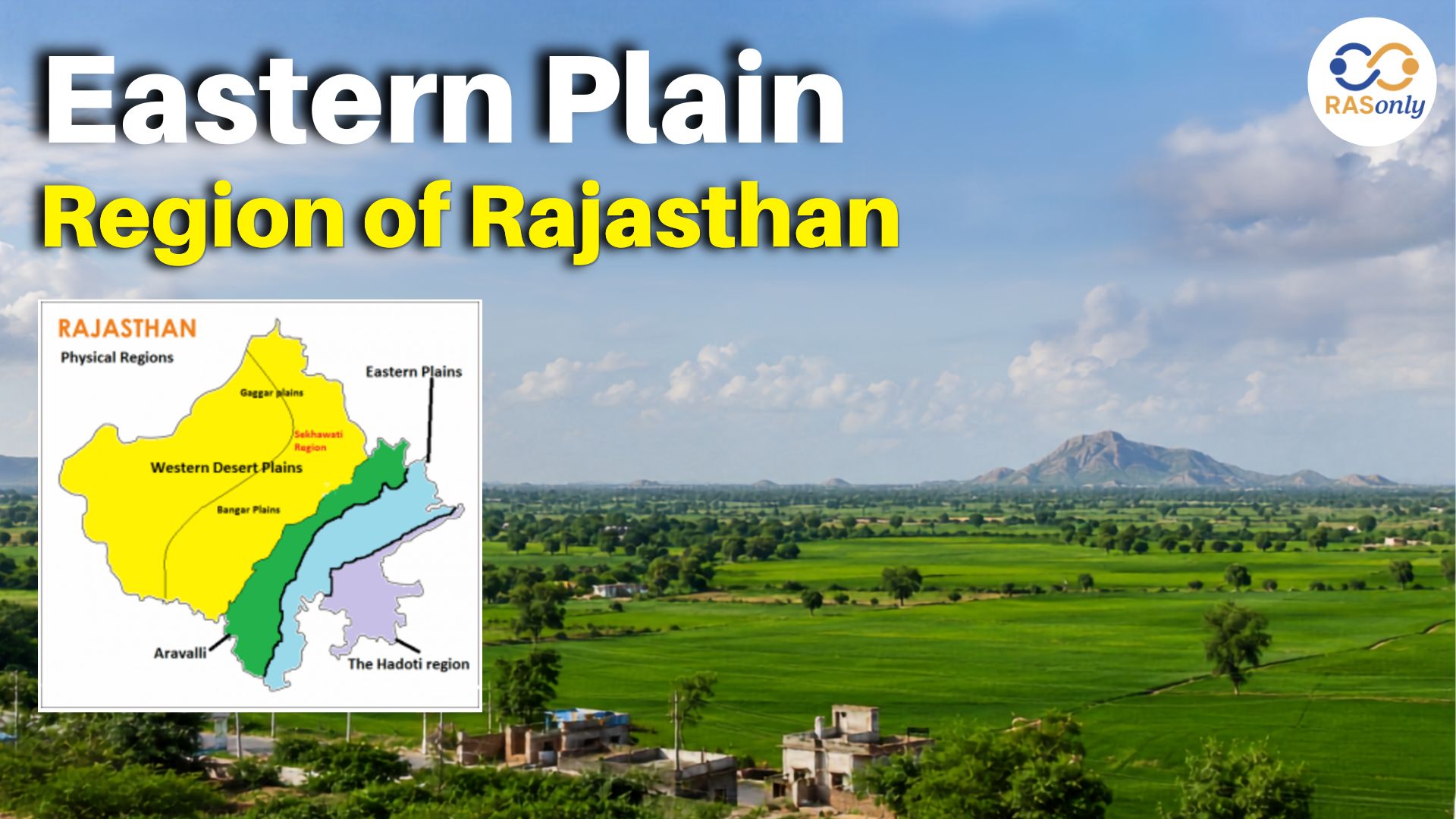
The Eastern Plain Region of Rajasthan is one of the four major physical regions of Rajasthan, which is considered as the most fertile and populated region of the state. The Rajasthan Eastern Plain lies between the Aravalli Range on the west and the Hadoti Plateau on the east, covering almost 23% of the State of Rajasthan and supporting almost 39% population of the State.
This is because of the presence of a network of rivers in this region, the major ones are Banas, Banganga, and Chambal, which, over centuries, have deposited thick layers of alluvial soil. Consequently, the geography of the Eastern Plains of Rajasthan is quite different from the arid western Thar Desert with green belts of agriculture, increased rainfall and much more dense human settlements. It is very important to know about this region for students of Rajasthan GK, RAS aspirants and students who are interested in the geography of the state.
Location and Extent
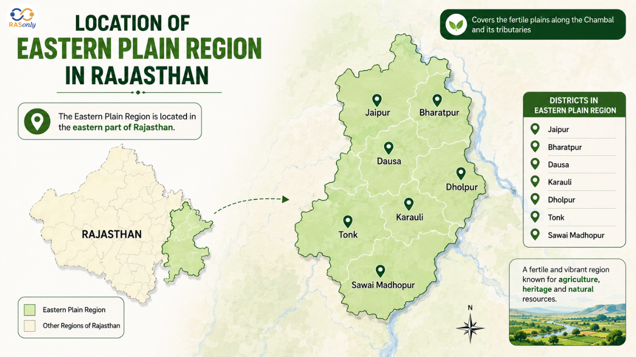
The Eastern Plain forms part of the larger Rajasthan physical divisions, bordered by the Aravalli Hills on the west and the Vindhyan/Hadoti Plateau on the southeast. It is distributed around the northeastern and southeastern regions of the state, encompassing broad areas of districts like Jaipur, Dausa, Bharatpur, Alwar (partly), Sawai Madhopur, Karauli, Dholpur, Tonk, Bhilwara, Dungarpur, Banswara, and Pratapgarh.
Key facts about the region
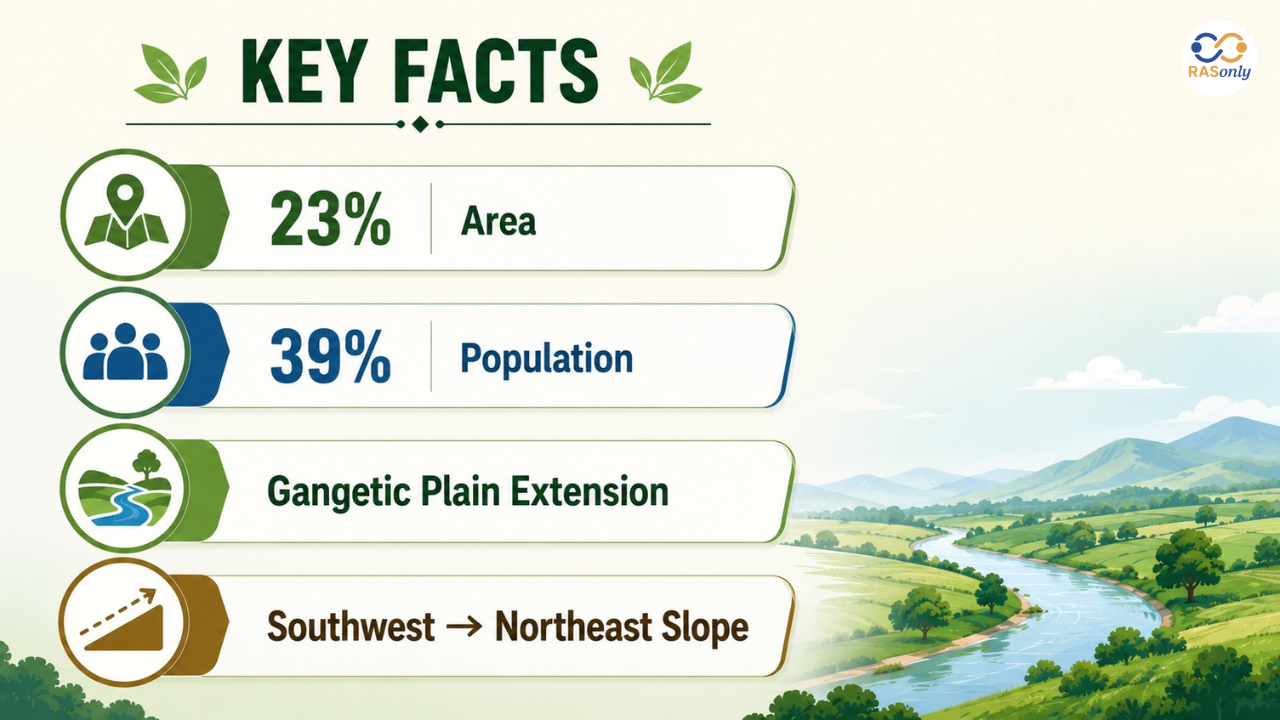
- Covers approximately 23% of Rajasthan's total geographical area
- Home to nearly 39% of the state's population, making it the most densely populated physical division
- It is composed mainly of the rivers Banas, Banganga, and Chambal.
- Considered a westward extension of the Gangetic plain
- The general slope of the region runs from southwest to northeast, though sub-regions vary
Eastern Plain Region Features
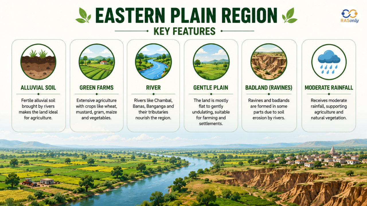
The Eastern Plain region features that distinguish it from the rest of Rajasthan include its relatively higher rainfall, fertile alluvial soil, gentle undulating terrain, and dense river network. This plain, with its fertile terrain, has been the home of great kingdoms and cultural hubs in the past, and is ideal for intensive farming, in contrast to the more arid regions of western Rajasthan.
Some defining characteristics:
- Alluvial and brown soil cover most of the plain, ideal for crops like wheat, mustard, and maize
- Moderate to good rainfall compared to the desert region, supporting both irrigated and rain-fed agriculture
- Undulating to gently sloping terrain, with elevation generally ranging between 200 and 500 metres above sea level
- Presence of badland topography (ravines) along the Chambal River, locally known as "Dang" or beehad land
- High population density due to favourable farming conditions and water availability
Sub-Divisions of the Eastern Plain
Generally, the Rajasthan Eastern Plain is broken up into various sub-plain areas using the river systems that drain them and the soils they have.
| Sub-Region | Main River(s) | Districts Covered | Key Feature |
|---|---|---|---|
| Banas Basin | Banas and tributaries (Berach, Kothari, Khari, Menal) | Bhilwara, Rajsamand, Chittorgarh, Ajmer, Tonk | Elevated plain with brown soil; further divided into Mewar Plain and Malpura-Karauli Plain |
| Banganga Plain | Banganga River | Jaipur, Dausa, Bharatpur | Fertile alluvial soil, intensive agriculture |
| Chambal Plain | Chambal and tributaries (Kali Sindh, Parvati) | Kota, Bundi, Sawai Madhopur, Karauli, Dholpur | Known for ravines (badlands) formed due to gully erosion |
| Vagad Plain (Mahi Basin) | Mahi River | Dungarpur, Banswara, Pratapgarh | Red loamy soil, suitable for rice, maize, and sugarcane cultivation |
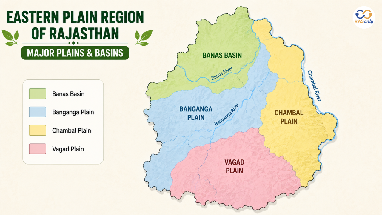
The nature of soils and drainage characteristics in the Banas basin Rajasthan, and Chambal river plains are different, and this classification emphasizes the combination of these two areas as the core of this fertile tract.
Rivers of the Eastern Plain
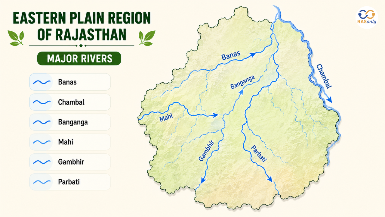
The rivers of Eastern Rajasthan are the lifeline of this area as far as the landscape and agricultural economy are concerned.
- Banas River – The longest among all the tributaries of the Chambal River, originating from the Khamnaur Hills of Rajsamand district, entirely in the state of Rajasthan.
- Chambal River- It is the main river that comes into Rajasthan from Madhya Pradesh and the lower portion of the river has numerous deep gorges and badland topography.
- Banganga River – passes through Jaipur, Dausa, and Bharatpur and provides fertile alluvial plains.
- Mahi River – Drains the southern part of the region (Banswara, Dungarpur, Pratapgarh), flowing towards the Gulf of Khambhat.
- Smaller but important tributaries that add to the eastern tract's drainage system include the Gambhir and Parbati Rivers.
Soil and Agricultural Importance
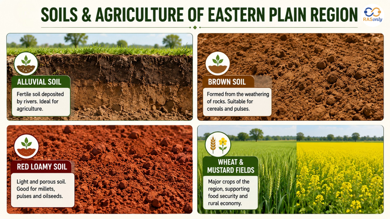
The fertile plains of Rajasthan are in large part due to the alluvial and brown soils brought by these river systems. This makes the Eastern Plain the most agriculturally productive part of the state.
- The Banganga and lower Chambal plains are predominantly alluvial soil and wheat, barley, and mustard are grown here.
- Brown soil is common in the Banas basin, suitable for a variety of rabi and kharif crops
- Red loamy soil in the Vagad (Mahi basin) region favours rice, maize, and sugarcane
- Extensive use of well and canal irrigation due to shallow groundwater levels compared to western Rajasthan
- The area plays a significant role in the statewide foodgrain and oilseed production and is an important part of the agricultural economy of Rajasthan.
Climate of the Eastern Plain Region
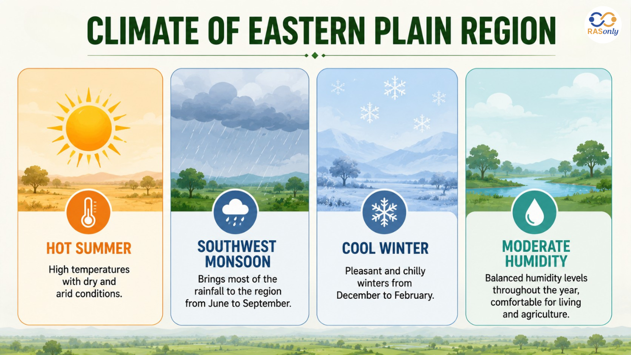
Compared to the semi-arid to arid climate of western Rajasthan, the climate here is comparatively moderate.
- Receives higher average rainfall than the Thar Desert region, mostly through the southwest monsoon
- Hot summers and comparatively cool winters for the crop of rabi.
- The relative humidity is high in the vicinity of the Chambal and Mahi basin areas and low in the northern plain areas.
- In years of weak monsoon activity, occasional dry spells occur, but the region is never as dry as is sometimes found in the western districts.
Difference Between Eastern Plain and Aravalli Hills
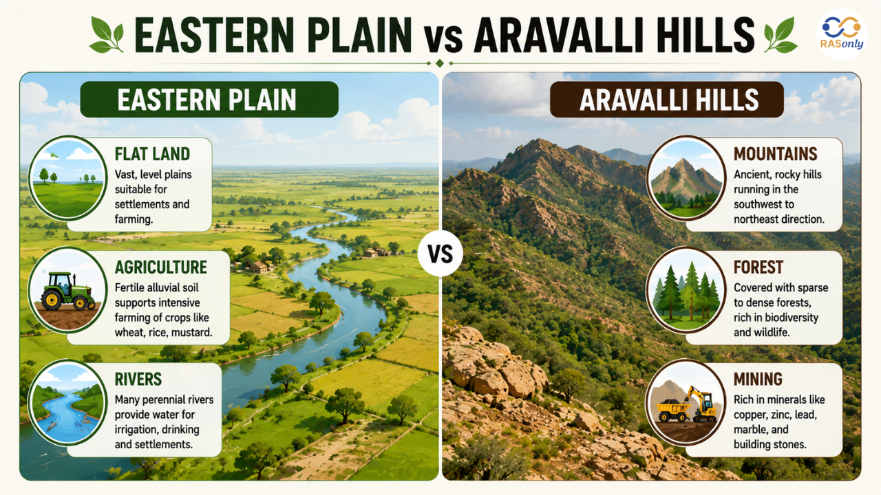
Many students often confuse the Eastern Plain with the adjoining Aravalli Hills region. The table below clarifies the distinction.
| Aspect | Eastern Plain | Aravalli Hills Region |
|---|---|---|
| Terrain | Flat to gently undulating plain | Rugged hills and ridges |
| Soil | Alluvial, brown, red loamy | Rocky, thin soil cover |
| Main Rivers | Banas, Banganga, Chambal, Mahi | Origin point for Banas, Luni, Sabarmati and other rivers |
| Population Density | High | Comparatively lower |
| Economic Activity | Agriculture-dominated | Mining, forestry, and limited agriculture |
Importance in Rajasthan's Economy and Exams
The Eastern Plain region is essential not only in terms of agriculture, but also in terms of the number of people residing in and its administrative setup, with some of the densest districts in Rajasthan, including the state capital, Jaipur. It is a very common question asked in competitive exams like RAS, REET, Patwari and other exams based on Rajasthan GK in the context of physical divisions, drainage system and soil classification of Rajasthan.
Aspirants preparing for the Eastern Plain Region of Rajasthan for the RAS exam should focus on:
- Names and courses of major rivers (Banas, Chambal, Banganga, Mahi)
- District-wise classification of sub-regions
- Soil types and their associated crops
- Comparative features with the Aravalli and Hadoti regions
Conclusion
The Eastern Plain Region of Rajasthan is the agricultural and demographical heartland of the state due to the Banas, Banganga, Chambal, and Mahi river systems having formed this region over the years. This land is clearly differentiated from the arid Thar Desert and the rugged terrain of the Aravallis by its fertile alluvial soils, moderate climate, and higher population density. This area is one of the most important topics in the physical geography of Rajasthan for academic study, competitive exam preparations, and general understanding of geographical knowledge.
FAQs
The Eastern Plain Region of Rajasthan is one of the four major physical divisions of the state. It is the most fertile and densely populated region, covering about 23% of Rajasthan's geographical area and supporting nearly 39% of its population due to fertile alluvial soils and an extensive river network.
The major rivers flowing through the Eastern Plain Region are Banas, Chambal, Banganga, and Mahi. The Gambhir and Parbati rivers are also some of the other important tributaries, which provide irrigation and soil fertility.
The region includes major parts of Jaipur, Dausa, Bharatpur, Alwar (partly), Sawai Madhopur, Karauli, Dholpur, Tonk, Bhilwara, Dungarpur, Banswara, Pratapgarh, Rajsamand, Chittorgarh, Ajmer, Kota, and Bundi districts.
The area enjoys good agricultural potential due to the presence of thick beds of alluvial soil laid down by rivers, such as the Banas, Chambal, Banganga and Mahi, over many centuries. With moderate rainfall and irrigational systems, these conditions are good for agricultural activities.
The region mainly has alluvial soil, brown soil, and red loamy soil. Alluvial soil dominates the Banganga and Chambal plains, brown soil is common in the Banas Basin, while red loamy soil is found in the Vagad (Mahi Basin) region.

BEST SELLER
🏆 PRELIMS
RAS Pass
Prelims focused Hindi & English
₹399
✓
Prelims Topic-Wise Tests
✓
Subject-Wise Tests
✓
Full-Length Prelims Tests
✓
Daily Current Affairs Tests
✓
Prelims PYQs Tests
✓
Detailed Solutions & Analysis
✓
All Rajasthan Ranking
✓
Unlimited Reattempts
✓
Mains Tests
✓
Hindi & English Tests
✓
All Rajasthan Ranking
Trusted by 5,000+ Students
Post Category
- RAS Salary
- Result
- RAS Admit Card
- RAS Job
- RAS Cutoff
- Preparation Tips
- RAS Answer Key
- RAS Exam Analysis
- RAS Syllabus
- RAS Previous Year Papers
- RPSC RAS Exam Pattern
- RAS Interview
- RAS Exam Date
- RAS Vacancy
- RAS Test Series
- RAS Best Books
- RAS Preparation Resources
- RAS Coaching Centre
- History
- Polity
- Geography
- Economics
- Science
- Art and Culture
- RPSC RAS Application Form
- RPSC RAS Notification
- RAS Eligibility Criteria
- UPSC Exam
- RPSC RAS Mains
Visit Our RASonly Offline Center
Our Expert Faculty

Bhunesh Sir
Current Affairs · 13+ Yrs

Aamir Khan Sir
RAS-2017 · IIM Ahm.

Akash Sir
Polity · 8+ Yrs
Free Resources
Official Mobile App

RASOnly App
by OTSAdda · Free
Full Video Lectures
Mock Tests & PYQs
Daily Current Affairs
AI Mock Interview
Free Download · No subscription needed to install
RAS 2024 Toppers — RASonly
Rank 2
Virendra Charan
Rank 9
Bhoopinder Singh
Rank 26
Aanchal Nagpal
Rank 33
Lokendra Singh
Rank 45
Amar Rathore
Rank 46
Manasvini Verma

Join RASonly WhatsApp Community
Get daily current affairs, exam alerts, free study material and tips from expert faculty — right on WhatsApp.
Join for Free →RASonly Interview Guidance Program

Mr. Ashok Jain
Ex-Chief Secretary Govt of Rajasthan
- IAS officer of the 1981 batch, Rajasthan cadre.
- Passionate about mentoring the next generation of RAS officers with real-world insights.
- Got retired in Dec 2017 from the post of Chief Secretary of the state of Rajasthan.

Mr. Guru Charan Rai
Ex-ASP / SP in Jaisalmer
- Guru Charan Rai, IPS (Retd), retired as Inspector General of Police (Security), Rajasthan, Jaipur in 2017.
- Served as ASP and SP in Jaisalmer, Nagaur, Sri Ganganagar, Sawai Madhopur, Dausa, Sikar, and Karauli.
- He also held key positions as DIGP and IGP in the Law and Order division.

Mr. Rakesh Verma
Ex-IAS Officer, B.Tech, MBA, and M.A. (Economics)
- IAS officer of the 1981 batch and retired in Chief Secretary Rank.
- Civil servant of high repute and vast experience.
- Has been teaching UPSC CSE subjects for the last six years.
Related Post

Daily Current Affairs for RAS Exam Preparation 2026
Rajasthan Initiative to Build India’s First UNESCO Global Geopark
October 07, 2026
Indigenous Tejas Mk-1 Inducted into IAF
October 07, 2026
Vedanta to Increase Oil Production in Rajasthan
October 06, 2026